Pass Your Coast Guard Licensing Exams!
Study offline, track your progress, and simulate real exams with the Coast Guard Exams app
Navigation General
91 images
Question 41
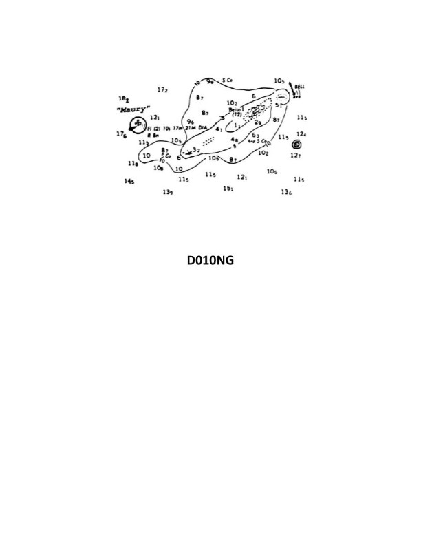
Question: Which statement concerning the chartlet in illustration D010NG below is true? (Soundings and heights are in meters)
A. Maury Lightship swings about her anchor on a circle with a 21-meter diameter.
B. There is a 12-meter deep hole inside the 5-meter curve just west of Beito Island.
C. The position of the lightship is indicated by the center of the star on the symbol's mast.
D. The sunken wreck southwest of Beito Island shows the hull or superstructure above the sounding datum.
The correct answer is D) The sunken wreck southwest of Beito Island shows the hull or superstructure above the sounding datum. This is correct because the chartlet indicates a sunken wreck symbol southwest of Beito Island, which implies that a portion of the wreck is visible above the sounding datum (the reference water level used for the depth soundings shown on the chart). The other options are incorrect because: A) the chartlet does not provide information about the Maury Lightship's swing circle diameter, B) there is no 12-meter deep hole indicated near Beito Island, and C) the position of the lightship is indicated by the center of the star symbol, not the mast.

Question 51
Question: A daymark used to indicate the starboard side of the channel when approaching from seaward will have the shape indicated by what letter in illustration D045NG below?
A. A
B. B
C. C
D. D
The correct answer is D. The shape indicated by the letter D in illustration D045NG represents a daymark used to indicate the starboard side of the channel when approaching from seaward. This is because daymarks in the shape of a triangle pointing upwards are used to mark the starboard side of a channel, as per the U.S. Aids to Navigation System. The other answer choices (A, B, and C) represent different shapes that are used for different purposes, such as marking the port side of a channel or serving as regulatory markers, and are therefore incorrect for indicating the starboard side of a channel.
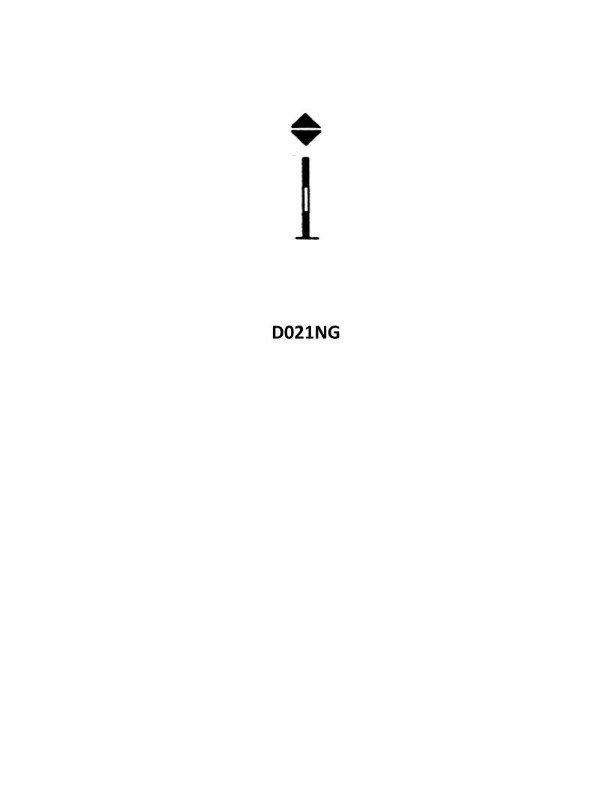
Question 57
Question: While proceeding along the Norwegian coast on course 039°T, you sight the black- yellow-black banded buoy shown in illustration D021NG below, bearing 053°T. What action should you take?
A. Alter course to 053° and leave the buoy close aboard on either side
B. Alter course to port to rapidly open the bearing to the right
C. Maintain course
D. Alter course to 060° and ensure that the true bearings decreases
The correct answer is D. Alter course to 060° and ensure that the true bearing decreases. This is the correct answer because the black-yellow-black banded buoy is a special-purpose buoy that indicates a channel or fairway. When a special-purpose buoy is sighted, the proper action is to alter course to ensure that the bearing to the buoy decreases, indicating that you are passing it on the safe side. Altering course to 060° and verifying that the true bearing decreases would accomplish this. The other options are incorrect because they do not properly account for the meaning and proper response to a special-purpose buoy. Altering course to 053° or opening the bearing to the right would not necessarily ensure safe passage of the buoy.
Question 77
Question: A daymark used as a special mark is indicated by which letter in illustration D045NG below?
A. A
B. B
C. C
D. D
The correct answer is B. According to the U.S. Coast Guard's Navigation Rules and Regulations Handbook, a special mark used to indicate a daymark is indicated by the letter B. Special marks are used to mark areas that are not considered the main navigational channel, such as traffic separation schemes, offshore structures, or other special areas. The letter B within illustration D045NG confirms that the special mark depicted is the correct indication for a daymark. The other answer choices are incorrect because A, C, and D do not correspond to the marking for a special daymark as per the Coast Guard regulations.
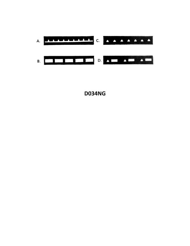
Question 100
Question: Which item in illustration D034NG below shows an occulting light?
A. A
B. B
C. C
D. D
The correct answer is B. The illustration D034NG shows different types of navigation lights, and the occulting light is represented by item B. An occulting light is a light that appears and disappears at regular intervals, with the duration of the light phase being longer than the duration of the eclipse phase. This type of light is commonly used to mark fixed objects, such as navigational aids or structures, to help mariners identify their location and avoid potential hazards. The other answer choices do not represent an occulting light. A represents a flashing light, C represents a fixed light, and D represents a quick-flashing light, which have different characteristics and applications in maritime navigation.
Question 117
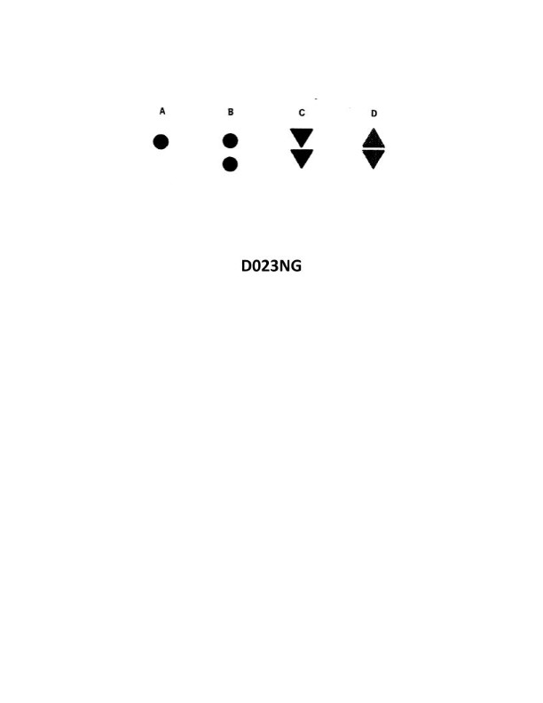
Question: Which topmark shown in illustration D023NG below identifies an isolated danger?
A. A
B. B
C. C
D. D
The correct answer is B. The topmark shown in illustration D023NG that identifies an isolated danger is a single black sphere. This is in accordance with the International Association of Lighthouse Authorities (IALA) Maritime Buoyage System, which specifies that an isolated danger mark should display a single black sphere as the topmark. The other answer choices do not correctly identify the topmark for an isolated danger mark. A, C, and D represent different topmarks used for other types of navigational marks, such as cardinal marks or safe water marks, but not for isolated danger marks.
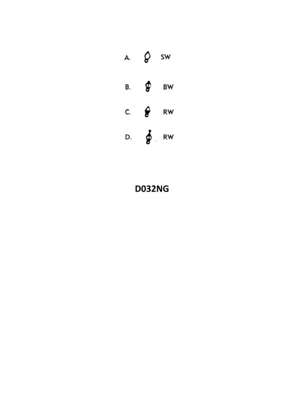
Question 122
Question: Which of the buoy symbols shown in illustration D032NG below indicates a safe water mark?
A. B
B. C
C. A
D. D
The correct answer is D. The safe water mark, also known as a fairway buoy, is represented by the symbol D in the illustration. This buoy is used to mark the center of a navigable channel or fairway, indicating that it is safe for vessels to pass on either side. The other options (A, B, and C) represent different types of buoys, such as port and starboard side markers, which are used to delineate the edges of a channel and should not be crossed by vessels.
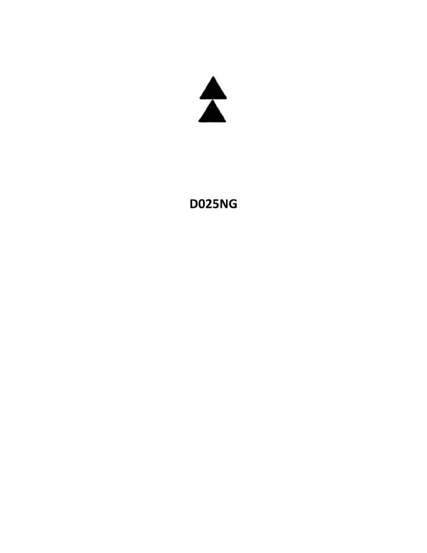
Question 133
Question: You are underway on course 127°T. You sight a buoy with the topmarks shown in illustration D025NG below, bearing two points on the starboard bow. Which action must be taken?
A. Ensure the bearings change to the right.
B. Alter course to port until the buoy is broad on the starboard quarter, then hold course.
C. Change course to have the buoy close aboard either side.
D. Alter course to starboard until the buoy is at least two points on the port bow, then hold course.
The correct answer is A) Ensure the bearings change to the right. The reason this is the correct answer is that the topmarks shown in illustration D025NG indicate a port-hand lateral mark, which means the buoy is marking the port side of the channel. When a port-hand lateral mark is two points on the starboard bow, the proper action is to ensure the bearings change to the right, indicating that the vessel is proceeding in the proper direction along the channel. The other answer choices are incorrect because they do not align with the proper response for a port-hand lateral mark in this situation. Altering course to port, changing course to close aboard either side, or altering course to starboard would not be the appropriate actions to take.
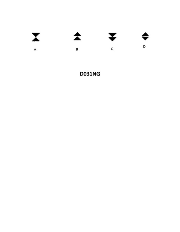
Question 136
Question: In the North Sea area, you sight a buoy showing a quick white light showing 6 flashes followed by one long flash at 15 second intervals. Which of the four topmarks in illustration D031NG below would be fitted to this buoy?
A. A
B. B
C. C
D. D
The correct answer is C. The characteristics of the light described (quick white light showing 6 flashes followed by one long flash at 15 second intervals) indicate that this is a composite group flashing white light, which is associated with a special purpose buoy according to the IALA Buoyage System. The topmark shown in option C, consisting of two black spheres, is the standard topmark used to identify a special purpose buoy. The other options do not match the characteristics of the light described, and would not be the appropriate topmark for this type of buoy.
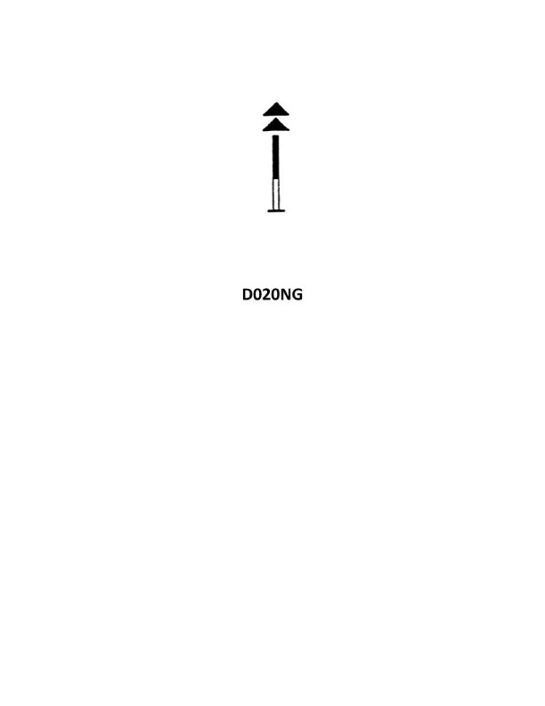
Question 138
Question: While proceeding along the Mediterranean coast of Spain, you sight the black and yellow buoy shown in illustration D020NG below. Your course is 039°T, and the buoy bears 053°T. What action should you take?
A. Alter course towards the buoy and leave the buoy well clear on either side
B. Alter course to 053°T and pass the buoy close aboard on either side
C. Alter course to 060° and ensure that the bearings decrease
D. Maintain course and ensure that the bearings increase
The correct answer is D) Maintain course and ensure that the bearings increase. This is the correct answer because when a buoy is sighted on your starboard side and the bearing to the buoy is increasing, it indicates that you are passing the buoy on the safe side (to the starboard). By maintaining your current course of 039°T, the bearing to the buoy will continue to increase, confirming that you are proceeding safely past the buoy. The other options are incorrect because altering course towards the buoy (A) or altering course to the bearing of the buoy (B) would put you at risk of colliding with the buoy. Altering course to 060° (C) would not be the appropriate action, as it would not ensure that the bearings continue to increase.
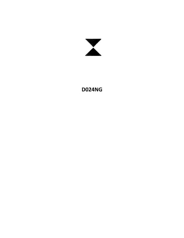
Question 142
Question: Which cardinal quadrant is represented by the topmark in illustration D024NG below?
A. Southern
B. Western
C. Eastern
D. Northern
The correct answer is B) Western. The topmark in illustration D024NG represents a Western cardinal mark, which is a single black sphere. According to the U.S. Coast Guard's Navigation Rules and Regulations, a single black sphere is the topmark that identifies a Western cardinal mark, which indicates that the safest water is to the west of the mark. The other answer choices are incorrect because a Southern cardinal mark has two black spheres, an Eastern cardinal mark has three black spheres, and a Northern cardinal mark has a single black cone point up.

Question 144
Question: On a voyage along the coast of France, you sight a buoy with the top marks as shown in illustration D026NG below. How should you steer your vessel?
A. west of the buoy
B. east of the buoy
C. south of the buoy
D. north of the buoy
The correct answer is C) south of the buoy. The top marks shown in illustration D026NG indicate a starboard hand buoy, which means vessels should pass to the south (or right) side of the buoy. This is a standard navigation rule for safe passage around buoys and other maritime markers. Passing to the south of the buoy ensures that you are keeping the buoy on your vessel's starboard (right) side, which is the proper procedure for safe navigation. The other answer choices are incorrect because passing west, east, or north of the buoy would not be the proper way to navigate around this starboard hand buoy according to standard maritime regulations.
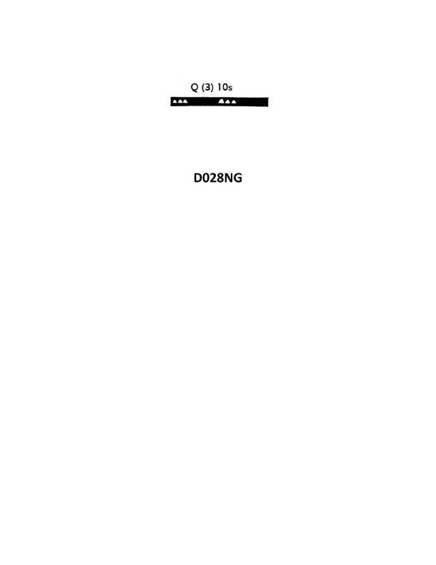
Question 148
Question: While steaming north of the Irish coast, you sight a buoy which shows the light rhythm shown in illustration D028NG below. How would you pass this buoy?
A. North of the buoy
B. West of the buoy
C. East of the buoy
D. South of the buoy
The correct answer is C) East of the buoy. This is because the illustration D028NG depicts a green flashing buoy, which indicates that the buoy should be passed on the green, or easterly, side. The International Association of Lighthouse Authorities (IALA) Buoyage System, which is used in the United States and many other countries, specifies that green buoys should be passed on the starboard (right) side when traveling northbound. Therefore, the vessel should pass the buoy to the east. The other answer choices are incorrect because passing the buoy to the north, west, or south would not be in accordance with standard navigational practices and the IALA Buoyage System.
Question 149
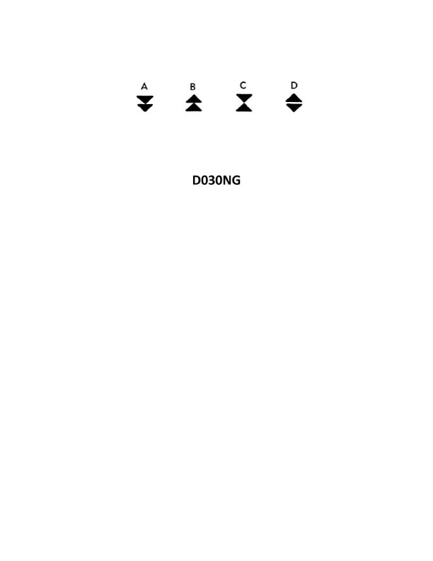
Question: During daylight hours black double-cone topmarks are the most important feature of cardinal marks. Which of the four topmarks shown in illustration D030NG below indicates the best navigable water lies to the west of the buoy?
A. A
B. B
C. C
D. D
The correct answer is C. The black double-cone topmark indicates a west cardinal mark, which means the best navigable water lies to the west of the buoy. This is according to the International Association of Lighthouse Authorities (IALA) buoyage system used in the United States. The other topmark options do not represent the west cardinal mark, so they would not indicate the best navigable water is to the west.
Question 155
Question: In the North Sea area, you sight a buoy showing a quick white light with 6 flashes, followed by one long flash at 15 second intervals. Which of the four topmarks shown in illustration D030NG below would be fitted to this buoy?
A. A
B. B
C. C
D. D
The correct answer is A. The key characteristic of this buoy is the quick white light with 6 flashes followed by one long flash at 15 second intervals. This pattern corresponds to the Fairway Buoy, which according to the IALA Buoyage System is marked with a topmark of two black cones point-to-point (option A). The other topmark options B, C, and D do not match the buoy's light characteristics, and would be used to mark different types of buoys in the IALA system, such as port-hand, starboard-hand, or isolated danger markers.
Question 156
Question: In the North Sea area, you sight a buoy showing a quick white light with 9 flashes every 15 seconds. Which of the four topmarks shown in illustration D030NG below would be fitted to the buoy?
A. A
B. B
C. C
D. D
The correct answer is C. The quick white light with 9 flashes every 15 seconds indicates that the buoy is a special purpose buoy. According to the IALA Buoyage System, a special purpose buoy is marked with a topmark consisting of two black spheres (choice C). The other options are incorrect because A and B represent navigation buoys, while D represents a wreck marking buoy, none of which are appropriate for a special purpose buoy in the North Sea area.
Question 161
Question: In the North Sea area, you sight a buoy with a quick light showing 3 flashes every 10 seconds. Which topmark in illustration D030NG below would be fitted to this buoy under the IALA Buoyage Systems?
A. A
B. B
C. C
D. D
The correct answer is D. Under the IALA Buoyage System, a buoy with a quick light showing 3 flashes every 10 seconds would be fitted with a topmark consisting of three black spheres, as shown in illustration D030NG. This topmark configuration indicates that the buoy is marking a special feature or area, such as a wreck or a zone with specific navigational requirements. The other answer choices are incorrect because they depict different topmark configurations that do not match the lighting characteristics described in the question.
Question 162
Question: In the North Sea area, you sight a buoy showing an uninterrupted quick-flashing white light. Which of the four topmarks shown in illustration D031NG below will this buoy be fitted with under the IALA Buoyage system?
A. A
B. B
C. C
D. D
The correct answer is B. Under the IALA Buoyage system, a buoy showing an uninterrupted quick-flashing white light in the North Sea area would be fitted with topmark B, which is a double cone with the points upward. This configuration indicates that the buoy is marking the port (left) side of a channel when entering from the sea. The other topmark options are incorrect because A is a single cone point upward (starboard side), C is a single cone point downward (preferred channel), and D is a double cone with the points downward (starboard side).
Question 165
Question: In the North Sea area, you sight a buoy showing a quick white light with 9 flashes every 15 seconds. Which of the four topmarks shown in illustration D031NG below would be fitted to the buoy?
A. A
B. B
C. C
D. D
The correct answer is A. A quick white light with 9 flashes every 15 seconds indicates a safe water mark, which is a buoy or other aid used to mark the middle of a channel or other safe navigable waters. As per the International Association of Lighthouse Authorities (IALA) regulations, a safe water mark should display the topmark shown in option A - a single red sphere. The other options (B, C, and D) represent different topmarks used for different types of buoys and navigational aids, which would not be correct for a safe water mark displaying the described light characteristics.
Question 169
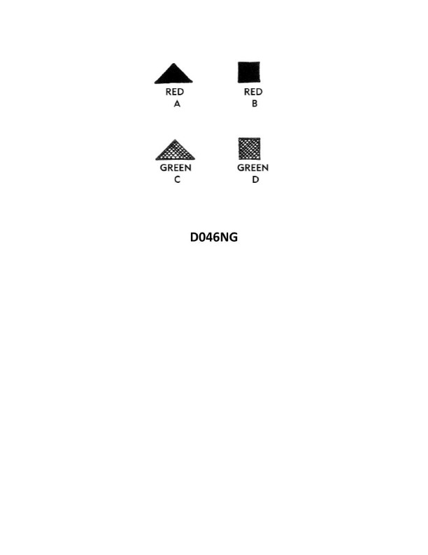
Question: Under the IALA-A Buoyage System, when entering from seaward a lateral system buoy to be left to port may display which topmark shown in illustration D046NG below?
A. A
B. B
C. C
D. D
The correct answer is B. Under the IALA-A Buoyage System, when entering from seaward, a lateral system buoy to be left to port may display a topmark of two black cones, point-up. This is depicted in illustration D046NG, option B. The other options are incorrect because: A shows a single black cone, which would indicate a buoy to be passed on the starboard side; C shows two black cones, point-down, which would indicate a buoy to be passed on the starboard side; and D shows a single black cylinder, which is not a standard topmark under the IALA-A system.
Question 174
Question: Under the IALA-A Buoyage System, when entering from seaward a lateral system buoy to be left to starboard may display which topmark shown in illustration D046NG below?
A. A
B. B
C. C
D. D
The correct answer is C. Under the IALA-A Buoyage System, when entering from seaward, a lateral system buoy to be left to starboard may display a conical (can) topmark, which is shown in illustration D046NG option C. This is because the conical topmark indicates a port-hand mark, which should be kept to the vessel's port (left) side when entering from the sea. The other options are incorrect because A and B show topmarks that do not correspond to the port-hand marking, and D shows a topmark that is not used in the IALA-A Buoyage System.
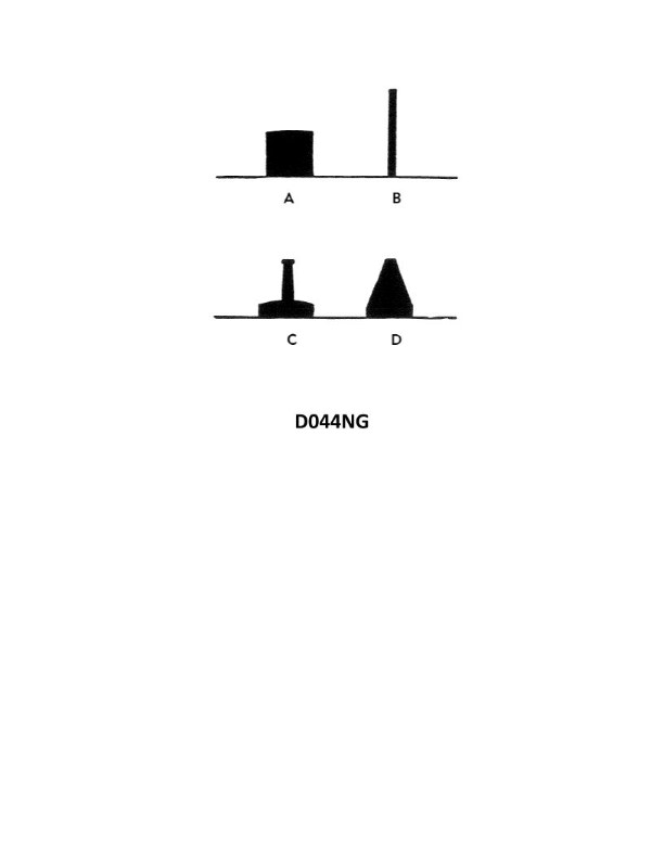
Question 211
Question: In illustration D044NG below, a pillar buoy is indicated by which letter?
A. A
B. B
C. C
D. D
The correct answer is C. In illustration D044NG, the pillar buoy is indicated by the letter C. This is based on the standard buoyage system used by the United States Coast Guard, where pillar buoys are typically marked with the letter C. The other answer choices are incorrect because A and B do not correspond to pillar buoys, and D is not indicated in the illustration.
Question 212
Question: Under the IALA-B Buoyage System, when entering from seaward a lateral system buoy to be left to port may display which of the topmarks shown in illustration D046NG below?
A. A
B. B
C. C
D. D
The correct answer is D. Under the IALA-B Buoyage System, a lateral system buoy to be left to port when entering from seaward may display the topmark shown in illustration D046NG, which is a single black cylinder. This topmark indicates that the buoy should be passed to the port side when entering from the seaward direction. The other answer choices are incorrect because they do not represent the proper topmark for a port-hand buoy under the IALA-B system. Options A, B, and C depict different topmark configurations that would not be used for this type of buoy.
Question 213
Question: In illustration D044NG below, what type of buoy is indicated by the letter A?
A. spar
B. nun
C. can
D. pillar
The correct answer is C) can. The illustration D044NG depicts a navigation buoy system, and the letter A indicates a can buoy. Can buoys are cylindrical-shaped navigational markers that are typically used to mark the sides of a channel or waterway. They are distinguished from other buoy types by their straight, cylindrical shape. The other answer choices are incorrect because: A) spar buoys have a tapered, narrow shape; B) nun buoys have a conical shape; and D) pillar buoys have a tall, narrow profile, unlike the cylindrical can buoy shown in the illustration.
Question 216
Question: In illustration D044NG below, what type of buoy is indicated by the letter D?
A. nun
B. pillar
C. can
D. spar
The correct answer is A) nun. The letter "D" in illustration D044NG indicates a nun buoy, which is a conical-shaped buoy that marks the port (left) side of a navigable channel when entering from the sea. Nun buoys have an even number and are painted red. The other answer choices are incorrect because: B) pillar buoys are cylindrical in shape, C) can buoys are cylindrical and mark the starboard (right) side of a channel, and D) spar buoys are vertical pole-like buoys used to mark isolated dangers or obstructions.
Question 236
Question: You are in a channel inbound from sea. A daymark used to mark a channel junction when the preferred channel is to starboard will have the shape indicated by what letter in illustration D045NG below?
A. A
B. B
C. C
D. D
The correct answer is A. A daymark used to mark a channel junction when the preferred channel is to starboard will have the shape indicated by the letter A in illustration D045NG. This is because the shape of the daymark (a triangular dayboard with the point down) indicates that the preferred channel is to the right, or starboard side, of the marker when traveling inbound from sea. The other answer choices are incorrect because they do not represent the shape of a daymark marking a preferred starboard channel. Choices B, C, and D depict different daymark shapes used for other navigational purposes.
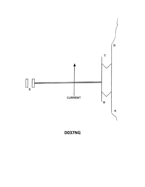
Question 238
Question: Illustration D037NG below represents a movable dam. If there is high water and the wickets are down so that there is an unobstructed navigable pass through the dam, what light(s) will be shown at B if the lock walls and piers are not awash?
A. One red light
B. Two red lights
C. Three red lights
D. One amber light
The correct answer is C) Three red lights. When the wickets on a movable dam are down and there is an unobstructed navigable pass through the dam, the Inland Navigation Rules require that three red lights be displayed at point B on the illustration to mark the lock walls and piers. This alerts mariners that the lock is closed and the area is obstructed, even though the dam itself does not pose a hazard. The other answer choices are incorrect because one red light would not be sufficient to mark the obstruction, two red lights would not meet the regulatory requirement, and an amber light would not be the proper color to mark a closed lock.
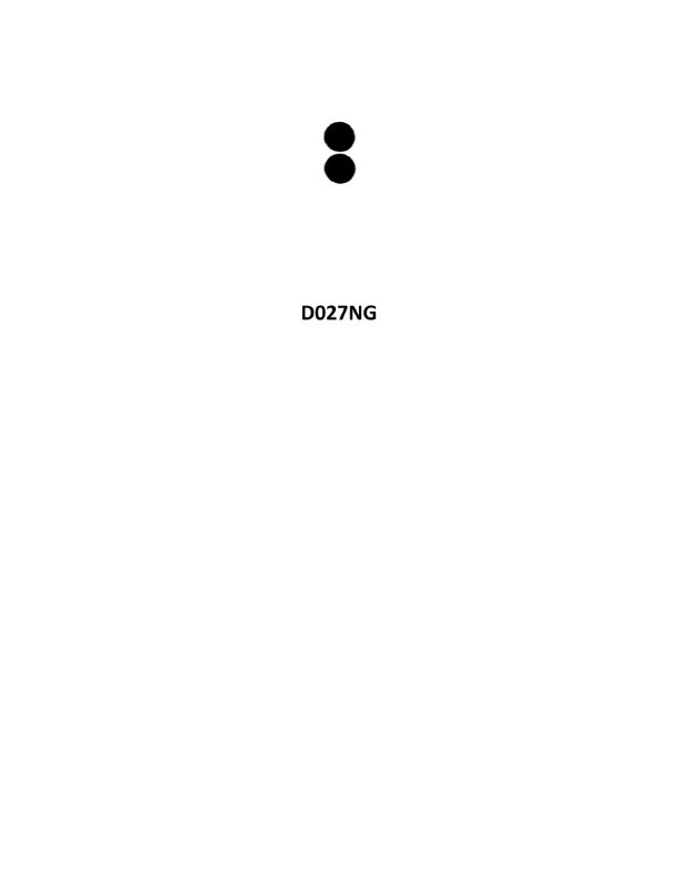
Question 255
Question: You sight a spar buoy with the topmark shown in illustration D027NG below. You must take which of the following actions?
A. pass to the east of the buoy
B. pass to the south of the buoy
C. pass to the north of the buoy
D. keep well clear of the buoy and pass on either side
The correct answer is D) keep well clear of the buoy and pass on either side. The illustration D027NG shows the topmark for a special purpose buoy, which indicates that the buoy marks an obstruction or danger. As per the US Coast Guard regulations, mariners should keep well clear of special purpose buoys and pass on either side to avoid the hazard they mark. Options A, B, and C would involve passing too close to the obstruction, which is not the recommended action.
Question 263
Question: Which statement concerning the chartlet seen in illustration D010NG below is TRUE? (Soundings and heights are in meters)
A. Maury lightship is visible for 17 miles.
B. There is a dangerous eddy southeast of Beito Island.
C. There is a 12-meter deep hole west of Beito Island and inside the 5-meter line.
D. The bottom to the south-southeast of the lightship is soft coral.
The correct answer is B) There is a dangerous eddy southeast of Beito Island. The chartlet shows a hazardous eddy symbol southeast of Beito Island, indicating the presence of a dangerous eddy in that area. This is the only answer choice that is supported by the information provided in the illustration. The other answer choices are incorrect because: A) The chartlet does not provide information about the visibility range of the Maury lightship. C) The chartlet does not show a 12-meter deep hole west of Beito Island. D) The chartlet does not indicate the type of bottom material south-southeast of the lightship.
Question 268
Question: Under the IALA-B Buoyage System, when entering from seaward a lateral system buoy to be left to starboard may display which of the topmarks shown in illustration D046NG below?
A. A
B. B
C. C
D. D
The correct answer is A. Under the IALA-B Buoyage System, when entering from seaward a lateral system buoy to be left to starboard, the buoy may display a conical (nun) topmark as shown in illustration D046NG, option A. This topmark indicates that the buoy should be passed to the starboard (right) side when approaching from the sea. The other options, B, C, and D, represent different topmark shapes that would not be used for a starboard-hand lateral buoy in the IALA-B system. The key is that the conical (nun) shape in option A specifically denotes a starboard-hand buoy that should be passed to the right when entering from the seaward side.
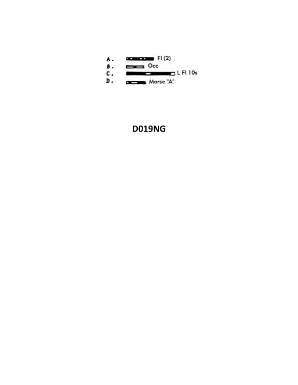
Question 311
Question: Of the four light characteristics shown in illustration D019NG below which one does NOT represent a safe water mark of the IALA Buoyage System?
A. A
B. B
C. C
D. D
The correct answer is A. The IALA Buoyage System defines four primary light characteristics: fixed, flashing, occulting, and isophase. Option A, which depicts a fixed light, does not represent a safe water mark in the IALA Buoyage System. Safe water marks are typically indicated by a white light with a red sector or a white light with a green and red sector. The other options, B (flashing), C (occulting), and D (isophase), can represent safe water marks in the IALA Buoyage System.
Question 312
Question: Under the IALA Buoyage System, which topmark shown in illustration D023NG below will be displayed on a safe watermark?
A. A
B. B
C. C
D. D
The correct answer is A. Under the IALA Buoyage System, a safe watermark will display the topmark shown in illustration D023NG, which is a single black sphere. This topmark indicates that the buoy or marker is on the safe water, meaning it is in the middle of the navigable channel or fairway. The other options are incorrect because B is a double black sphere (indicating a bifurcation or channel junction), C is a single black cone (indicating a port-hand mark), and D is a single black cylinder (indicating a starboard-hand mark). These topmarks have different meanings and are used to mark different types of navigational features.
Question 330
Question: Which item in illustration D034NG below shows a Morse
A. light
B. A
C. B
D. C
The correct answer is D) C. The illustration D034NG shows various nautical signal shapes and lights, and the question is asking which one represents a Morse light. The Morse light is a type of flashing light used for signaling, and the shape marked as "C" in the illustration is the correct representation of a Morse light. The other options are incorrect because A) shows a general light source, B) shows a flag, and C) shows a dayshape, none of which are specifically a Morse light.
Question 332
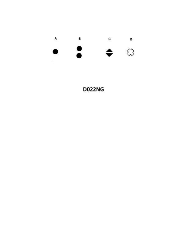
Question: In both regions of the IALA buoyage system, which topmark shown in illustration D022NG below is used on a special mark?
A. A
B. B
C. C
D. D
The correct answer is D. The IALA buoyage system (International Association of Marine Aids to Navigation and Lighthouse Authorities) specifies that a special mark, which is used to indicate a feature or location that is not a channel, must have a topmark in the shape of a single yellow X, as shown in illustration D022NG. This topmark configuration (option D) is the one used on special marks in both regions of the IALA system. The other options are incorrect because they do not match the topmark required for special marks under the IALA guidelines. Option A shows a single sphere, option B shows two cones, and option C shows a single cone - none of which are the correct X-shaped topmark for special marks.
Question 359
Question: You are in a channel inbound from sea. A daymark used to mark a channel junction, when the preferred channel is to port will have the shape indicated by what letter in illustration D045NG below?
A. A
B. B
C. C
D. D
The correct answer is D. According to the US Coast Guard regulations, a daymark used to mark a channel junction, when the preferred channel is to the port, will have a diamond shape. This diamond-shaped daymark is indicated by the letter D in illustration D045NG. The other answer choices (A, B, and C) do not represent the correct shape for a daymark indicating a preferred channel to the port at a channel junction.
Question 360
Question: In illustration D045NG below, a green-and-red banded daymark, with the uppermost band green, will have which of the following shapes?
A. A
B. B
C. C
D. D
The correct answer is A. A green-and-red banded daymark with the uppermost band green will have a triangular shape, as shown in option A. This is based on the U.S. Aids to Navigation System, which specifies that green-and-red banded daymarks with the uppermost band green indicate the shape of an isosceles triangle. The other options, B, C, and D, do not match the shape requirement for this type of daymark and are therefore incorrect.
Question 361
Question: In illustration D045NG below, what two shapes shown are used to indicate a preferred channel?
A. A and D
B. B and C
C. A and B
D. C and D
The correct answer is A) A and D. The two shapes used to indicate a preferred channel in illustration D045NG are the triangle (A) and the diamond (D). This is based on the regulations and conventions for navigational aids and channel markers used by the US Coast Guard. The triangle shape is used to mark the preferred side of a channel, while the diamond shape indicates the preferred channel itself. The other options, B and C, represent different navigational markers that are not used to indicate a preferred channel.
Question 363
Question: In illustration D045NG below, which shape is a daymark warning of danger?
A. A
B. B
C. C
D. D
The correct answer is B. The shape in illustration D045NG that represents a daymark warning of danger is a triangle. Daymarks are visual aids used to mark navigational hazards and channel edges. According to the United States Coast Guard regulations, a triangle daymark is used to indicate a navigational hazard or area to be avoided. The other shapes in the illustration (A, C, and D) represent different types of daymarks, such as a square for a channel edge or a diamond for a safe water mark, but do not specifically indicate a danger area.
Question 364
Question: A daymark used to indicate the safe water in a channel will have which of the shapes shown in illustration D045NG below?
A. A
B. B
C. C
D. D
The correct answer is C. A daymark used to indicate the safe water in a channel will have a cylindrical shape, as shown in illustration D045NG. This is in accordance with the U.S. Aids to Navigation System, which specifies that a cylindrical shape is used for safe water marks. The other options, A, B, and D, represent different shapes that are used for other types of navigational aids, such as lateral or special marks, but not for safe water marks.
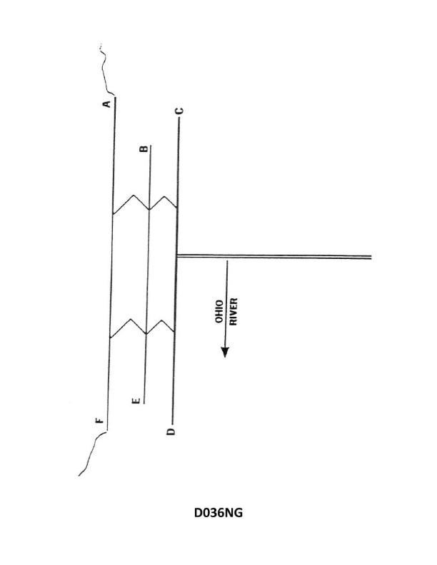
Question 382
Question: Illustration D036NG below represents a fixed C of E lock and dam. What navigational light(s) is(are) exhibited at the position indicated by the letter D?
A. Two green lights
B. Three green lights
C. One red light
D. No light
The correct answer is A) Two green lights. According to the U.S. Coast Guard Navigation Rules, for a fixed lock and dam structure like the one depicted in Illustration D036NG, the position indicated by the letter D would exhibit two green lights to mark the entrance to the lock. This is because green lights are used to mark the main channel or entrance to the lock, guiding vessels through the waterway. The other answer choices are incorrect, as a red light would be used to mark a side or secondary channel, and no light would not conform to the standard navigational lighting requirements for this type of structure.
Question 383
Question: Illustration D037NG below represents a movable dam. If there is high water and the wickets are down so that there is an unobstructed navigable pass through the dam, what light(s) will be shown at D if the lock walls and piers are not awash?
A. Three red lights
B. One amber light
C. One red light
D. Two red lights
The correct answer is C) One red light. When a movable dam has its wickets down and there is an unobstructed navigable pass through the dam, and the lock walls and piers are not awash, the lights to be shown at the dam are one red light, per the U.S. Aids to Navigation System. The red light indicates that the dam is closed to navigation and the passage is open. The other answer choices are incorrect because they do not match the regulation for the specific scenario described.
Question 412
Question: Which item in illustration D034NG below shows a fixed and flashing light?
A. A
B. B
C. C
D. D
The correct answer is A. Option A shows a fixed and flashing light, which is a common navigation light configuration for vessels. According to navigation regulations, this type of light combination is used to indicate the presence of a fixed structure, such as a pier or a jetty, with a flashing light superimposed on the fixed light to enhance visibility. The other options do not depict a fixed and flashing light, and therefore, they are not the correct answer.
Question 413
Question: Which item in illustration D034NG below shows a flashing light?
A. A
B. B
C. C
D. D
The correct answer is C. The illustration D034NG shows various navigational lights and signals, and the flashing light is represented by the item labeled C. This is in accordance with the U.S. Coast Guard regulations on navigation lights and signals, which require certain vessels to display flashing lights to indicate their status or maneuvers. The other options, A, B, and D, represent steady burning lights, which have different purposes and meanings compared to flashing lights. Therefore, C is the only option that correctly identifies the flashing light shown in the illustration.
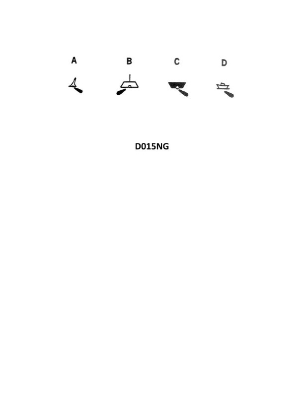
Question 473
Question: A large automated navigational buoy, such as those that have replaced some lightships, would be shown on a chart by which symbol in illustration D015NG below?
A. A
B. B
C. C
D. D
The correct answer is B. Large automated navigational buoys, such as those that have replaced some lightships, are depicted on nautical charts using the symbol shown in illustration B of D015NG. This is the standard symbol used to represent large, permanent buoys that serve as aids to navigation. The other options in the illustration do not accurately represent this type of navigational marker.
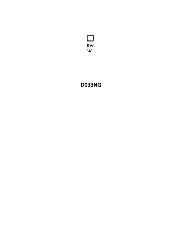
Question 475
Question: What does the symbol shown in illustration D033NG below indicate on a chart?
A. A red and white can buoy
B. A safe water beacon
C. A can buoy with a rotating white light
D. A sunken vessel marked by a buoy
The correct answer is B) A safe water beacon. The symbol shown in illustration D033NG represents a safe water beacon, which is a buoy or other marker that indicates an area of safe passage for vessels. Safe water beacons are typically green and white in color, and may have a variety of light characteristics, such as a flashing white light. The other answer choices are incorrect because they do not accurately describe the symbol shown. A red and white can buoy (A) is a different type of navigational aid, a can buoy with a rotating white light (C) is not the correct description, and a sunken vessel marked by a buoy (D) is not what the symbol represents.
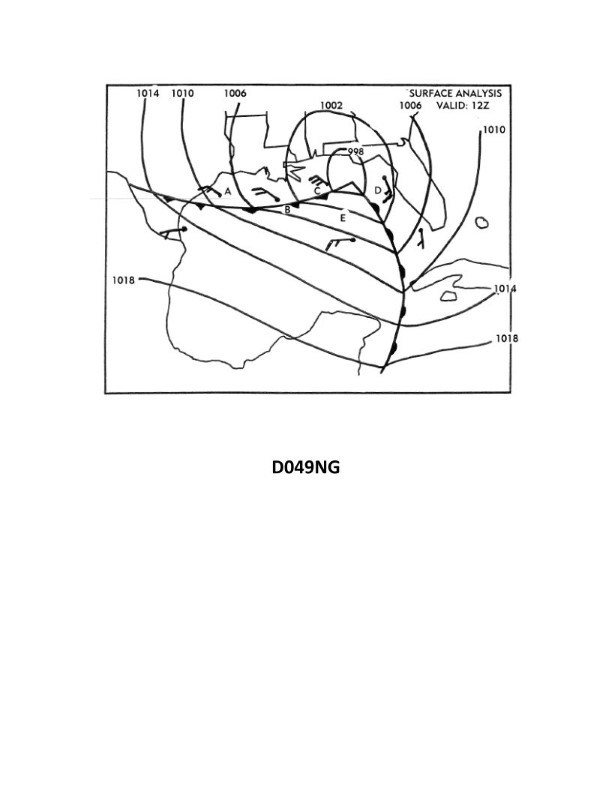
Question 694
Question: Using the surface analysis in illustration D049NG below, what weather conditions would you expect to find at position A?
A. winds SW-S at 20 knots, heavy rain, and rough seas
B. Winds NW-W at 15 knots, partly cloudy, and slight seas
C. Winds NE-E at 20 knots, heavy rain, and rough seas
D. Winds calm, light rain, and calm seas
The correct answer is B) Winds NW-W at 15 knots, partly cloudy, and slight seas. This is correct based on the surface analysis depicted in illustration D049NG. At position A, the isobars indicate a high pressure system, which typically brings calmer winds, partly cloudy skies, and slight seas. Winds in the northwestern quadrant of a high pressure system are generally NW-W at moderate speeds, which matches the conditions described in option B. The other options are incorrect because they do not align with the typical weather patterns associated with a high pressure system at the given location on the surface analysis chart.
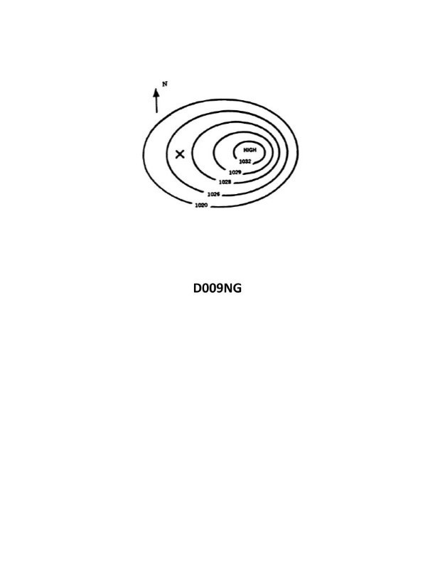
Question 699
Question: In illustration D009NG below, your position X is at LAT 35°S. Which winds are you experiencing?
A. Northwesterly
B. Southwesterly
C. Northeasterly
D. Southeasterly
The correct answer is C) Northeasterly. When your position is at latitude 35°S, you are experiencing winds from the northeast (northeasterly) because the wind flow in the southern hemisphere generally follows a counterclockwise pattern around areas of high pressure. This is known as the Coriolis effect, which causes the wind to be deflected to the left in the southern hemisphere. The other answer choices are incorrect because a position at 35°S would not experience northwesterly, southwesterly, or southeasterly winds, which would be more typical of locations further north or south of the equator.
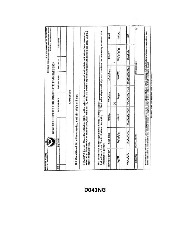
Question 724
Question: Your vessel is participating in the Voluntary Observing Ship Program. You are preparing WS Form B-80 as seen in illustration D041NG below. Three-quarters of the sky is covered with clouds, and the anemometer indicates that the apparent wind is from 226° relative at 17.7 knots. You are on course 020°T at 8 knots. How should you encode group Nddff?
A. 72318
B. 62324
C. 80208
D. 72218
The correct answer is B) 62324. To encode group Nddff, you need to determine the wind direction (dd) and wind speed (ff) based on the given information. The apparent wind is from 226° relative, and you are on course 020°T at 8 knots. This means the true wind direction is 226° - 020° = 206°. Rounding this to the nearest 10 degrees gives a wind direction of 21 (206° rounded to 210°). The anemometer indicates the apparent wind speed is 17.7 knots. Since you are moving at 8 knots, the true wind speed is 17.7 + 8 = 25.7 knots. Rounding this to the nearest 5 knots gives a wind speed of 25 knots. Therefore, the correct encoding for group Nddff is 62324, where 62 indicates 6/8 cloud cover, 32 indicates a wind direction of 210°, and 24 indicates a wind speed of 25 knots. The other options are incorrect because they do not accurately reflect the wind direction and speed based on the given information.
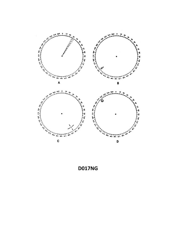
Question 727
Question: You are radar scanning for a buoy fitted with a racon. In illustration D017NG below, which radar screen represents the presentation you should expect on the PPI?
A. A
B. B
C. C
D. D
The correct answer is B. The illustration D017NG shows a buoy fitted with a racon (radar beacon). When a racon is detected by the radar, it will produce a distinct "dash" or "bloom" on the radar display, as shown in option B. This is the expected presentation on the PPI (Plan Position Indicator) when radar scanning for a buoy with a racon. The other options do not accurately represent the radar presentation of a racon-equipped buoy. Option A shows a simple target echo, option C depicts a more complex radar image, and option D does not appear to show a racon indication at all.
Question 730
Question: Your vessel is participating in the Voluntary Observing Ship Program, you are preparing WS Form B-80 as seen in illustration D041NG below. The sky is overcast, and the anemometer indicates that the apparent wind is from 144° relative at 8 knots. You are on course 162°T at 15 knots. How should you encode group Nddff?
A. 91521
B. 01615
C. 83322
D. 81408
The correct answer is C) 83322. To encode group Nddff, we need to follow the rules for the Voluntary Observing Ship Program and the WS Form B-80. For the given information: - The apparent wind is from 144° relative at 8 knots. - The vessel is on course 162°T at 15 knots. The correct encoding for Nddff is 83322, where: - N = 8 (wind direction from 144° relative) - dd = 33 (wind direction 144°) - ff = 22 (wind speed 8 knots) The other options are incorrect because they do not properly encode the given wind direction and speed information.
Question 832
Question: Your vessel is participating in the Voluntary Observing Ship Program, you are preparing WS Form B-80 as seen in illustration D041NG below. You are hove to in a hurricane on a heading of 328°T. The wind is from 030° true at 119 knots. How should this be encoded on the weather report form?
A. 83099
B. 83011
C. 80399
D. 80312
The correct answer is C) 80399. The reason this is the correct answer is that when encoding the wind direction and speed on the WS Form B-80 in a hurricane situation, the wind direction should be encoded as the true direction the wind is coming from (030°T in this case), and the wind speed should be encoded as the speed in knots (119 knots in this case). The encoding for this would be 80399, where 80 indicates the wind direction and 399 indicates the wind speed. The other answer choices are incorrect because they do not accurately represent the wind direction and speed information provided in the question.
Question 862
Question: Your vessel is participating in the Voluntary Observing Ship Program, you are preparing WS Form B-80 as seen in illustration D041NG below. Your position is LAT 64°42'N, LONG 02°28'W. How would this be encoded?
A. 9064N, 9025W
B. 0647N, 00025
C. 90647, 90024
D. 99647, 70025
The correct answer is D) 99647, 70025. The latitude of 64°42'N is encoded as 99647, with the first two digits representing the degrees (99 for 99 degrees) and the last three digits representing the minutes (647 for 42 minutes). The longitude of 02°28'W is encoded as 70025, with the first two digits representing the degrees (70 for 70 degrees) and the last three digits representing the minutes (025 for 28 minutes). The other options are incorrect because they do not accurately represent the latitude and longitude in the format required for the WS Form B-80 used in the Voluntary Observing Ship Program.
Question 863
Question: Your vessel is participating in the Voluntary Observing Ship Program, at 1800 ZT on 31 October your position is LAT 24°50'N, LONG 92°37'W. You are preparing WS Form B-80 as seen in illustration D041NG below. How should you encode the first three groups after the call sign if you estimate the wind?
A. 01003, 99248, 70926
B. 31243, 99249, 70926
C. 31123, 99929, 70249
D. 31183, 99249, 79237
The correct answer is A) 01003, 99248, 70926. The first three groups after the call sign on the WS Form B-80 correspond to the wind direction, wind speed, and pressure, respectively. At the given position and time, the wind direction should be encoded as 01003, indicating a wind from 010 degrees at 3 knots. The barometric pressure should be encoded as 99248, representing 992.8 millibars. The third group, 70926, correctly encodes the air temperature as 26.9 degrees Celsius. The other answer choices are incorrect because they do not accurately represent the wind direction, wind speed, and pressure values based on the information provided in the question.
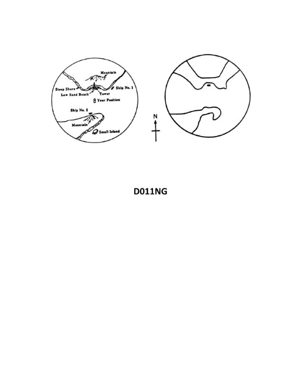
Question 881
Question: Illustration D011NG below represents the geographic location of a vessel and the radar presentation at the same time. Which statement is TRUE?
A. A tangent bearing of the headland to the south-southeast should be corrected by adding one- half of the beam width.
B. Ship No. 1 is not detected due to the shadow effect of the headland.
C. The small island is not detected due to the effect of beam width.
D. Ship No. 2 is not detected due to the reflective mass of the background mountain overpowering the ship's reflective signals.
The correct answer is A) A tangent bearing of the headland to the south-southeast should be corrected by adding one-half of the beam width. This is because when a vessel is close to a headland or other prominent feature, the radar image of that feature can distort the apparent bearing of the object. To correct for this effect, the tangent bearing should be adjusted by adding half the beam width of the radar beam. This helps account for the widening of the radar beam as it reflects off the headland. The other options are incorrect because: B) Ship No. 1 is likely detected, just obscured by the shadow effect of the headland; C) The small island may not be detected due to its small size, not the beam width; and D) Ship No. 2 is likely detected, but its reflection may be overpowered by the larger mountain in the background.
Question 897
Question: Your vessel is participating in the Voluntary Observing Ship Program, at 1200 ZT on 31 August, your position is LAT 43°14'S, LONG 175°44'E. You are preparing WS Form B-80 as seen in illustration D041NG below. How should you encode the first three groups after the call sign if you estimate the wind?
A. 31003, 99432, 31757
B. 31243, 94314, 31757
C. 31123, 99432, 31754
D. 01003, 94314, 51757
The correct answer is A) 31003, 99432, 31757. This is the correct answer because: 1. The first group (31003) represents the wind direction (310 degrees) and speed (3 knots), which is the estimated wind information based on the given position and time. 2. The second group (99432) represents the barometric pressure (994.3 hPa), which is a standard reporting element for the Voluntary Observing Ship Program. 3. The third group (31757) represents the sea surface temperature (31.7 °C), which is another standard reporting element for the program. The other options are incorrect because they do not accurately represent the wind direction, speed, and other required reporting elements for the Voluntary Observing Ship Program form.
Question 903
Question: Your vessel is participating in the Voluntary Observing Ship Program, you are preparing WS Form B-80 as seen in illustration D041NG below. The dry bulb thermometer reads 34°F and the wet bulb thermometer reads 31°F. How would you encode the air temperature groups in the report?
A. 10340, 2031/
B. 10340, 2127/
C. 10111, 2104/
D. 10011, 2104/
The correct answer is D) 10011, 2104/. This is correct because: 1. With a dry bulb temperature of 34°F and a wet bulb temperature of 31°F, the air temperature group should be encoded as 10011, which represents a temperature range of 30-34°F. 2. The second group, 2104/, represents the wet bulb temperature of 31°F. 3. The other answer choices do not accurately represent the given temperatures.
Question 911
Question: Your vessel is participating in the Voluntary Observing Ship Program, you are preparing WS Form B-80 as seen in illustration D041NG below. One-half of the sky is covered with clouds, and the anemometer indicates that the apparent wind is from 340° relative at 14 knots. You are on course 307°T at 12.6 knots. How should you encode group Nddff?
A. 43013
B. 53414
C. 54013
D. 42205
The correct answer is D) 42205. To encode the group Nddff, we need to consider the following information: - One-half of the sky is covered with clouds, which corresponds to cloud cover code N = 4. - The apparent wind is from 340° relative at 14 knots. Translating this to the ddff format, we get dd = 34 (340°) and ff = 14 (14 knots). The other options are incorrect because: A) 43013 does not match the given wind direction and speed. B) 53414 does not match the given cloud cover. C) 54013 does not match the given wind direction and speed.
Question 923
Question: Using the surface analysis in illustration D049NG below, what change in the wind direction could be expected at position "D" if the low were moving northeasterly?
A. Backing to the east
B. Veering to the north
C. Veering to the west
D. Backing to the north
The correct answer is C) Veering to the west. When a low-pressure system is moving northeasterly, the wind direction at position "D" would be expected to veer (change clockwise) to the west. This is because the counterclockwise circulation around the low-pressure system would cause the wind to shift in a clockwise direction as the system approaches from the southwest. The other options are incorrect because backing (changing counterclockwise) to the east or north would be the opposite of what is expected with a northeasterly moving low, and veering to the north would not be the typical wind shift associated with this weather pattern.
Question 960
Question: Using the surface analysis in illustration D049NG below, which wind speeds are reported at position A?
A. 10 knots
B. 15 knots
C. 20 knots
D. 25 knots
The correct answer is B) 15 knots. The illustration D049NG shows a surface analysis chart, which displays wind speed and direction information. At position A, the chart indicates a wind speed of 15 knots, as shown by the wind barb symbol. This is the only wind speed value that matches the answer choices provided. The other answer choices are incorrect because they do not match the wind speed reported at position A on the surface analysis chart. Option A (10 knots) and option C (20 knots) are not the correct wind speed, while option D (25 knots) is also not the wind speed shown at the specified location.
Question 971
Question: Illustration D011NG below represents the geographic location of a vessel and the radar presentation at the same time. Which statement is TRUE?
A. A tangent bearing of the headland to the south-southeast is corrected by subtracting one-half of the beam width.
B. Ship No. 2 is not detected due to the side lobe effect of radar reflecting from the mountain.
C. Ship No. 1 does not appear as an individual target due to the effect of beam width.
D. Small island is not detected due to the multiple echo effect from the mountain.
The correct answer is C) Ship No. 1 does not appear as an individual target due to the effect of beam width. This is correct because the radar beam width can be wide enough to encompass multiple targets within a single radar return, making them appear as a single target on the radar display. The illustration shows Ship No. 1 within the same radar beam as the headland, which would cause the individual target of Ship No. 1 to be obscured. The other answer choices are incorrect because: A) is about correcting bearings, not the radar presentation; B) the side lobe effect would not explain the missing target of Ship No. 2; and D) the multiple echo effect would not explain the missing island target, which is more likely due to the mountain's shadowing effect.
Question 1000
Question: Using the surface analysis in illustration D049NG below, what wind speed is reported in position C?
A. 3 knots
B. 10 knots
C. 20 knots
D. 30 knots
The correct answer is D) 30 knots. The surface analysis in illustration D049NG shows wind barbs, which indicate wind speed and direction. The wind barb at position C depicts a full wind barb and a half wind barb, which corresponds to a wind speed of 30 knots according to the standard wind barb symbology used in weather analysis. The other answer choices are incorrect because 3 knots (A) is too low, 10 knots (B) is too low, and 20 knots (C) is too low to match the wind barb depiction at position C in the surface analysis.
Question 1023
Question: Your vessel is participating in the Voluntary Observing Ship Program, you are preparing WS Form B-80 as seen in illustration D041NG below. The dry bulb thermometer reads 30°F (-1°C) and the wet bulb thermometer reads 28°F (-2°C). How would you encode the air temperature groups in the report?
A. 11300, 2124/
B. 10011, 2003/
C. 11011, 2104/
D. 11011, 2124/
The correct answer is C) 11011, 2104/. To encode the air temperature groups in the WS Form B-80 report, you need to use the dry bulb and wet bulb temperature readings. The dry bulb temperature of 30°F (-1°C) would be encoded as 11011, and the wet bulb temperature of 28°F (-2°C) would be encoded as 2104. Therefore, the complete air temperature groups would be 11011, 2104/. The other options are incorrect because: A) 11300, 2124/ does not correctly encode the wet bulb temperature. B) 10011, 2003/ does not correctly encode the dry bulb temperature. D) 11011, 2124/ does not correctly encode the wet bulb temperature.
Question 1035
Question: Your vessel is participating in the Voluntary Observing Ship Program, you are preparing WS Form B-80 as seen in illustration D041NG below. The dry bulb thermometer reads 78°F and the wet bulb thermometer reads 75°F. How would you encode the air temperature groups in the report?
A. 10256, 2023/
B. 00256, 0023/
C. 10780, 2074/
D. 10256, 2074/
The correct answer is A) 10256, 2023/. The air temperature groups are encoded using the dry bulb and wet bulb temperature readings. In this case, the dry bulb temperature is 78°F and the wet bulb temperature is 75°F. To encode these values, the first two digits (10) indicate the dry bulb temperature in whole degrees Celsius, which is 26°C. The next three digits (256) indicate the wet bulb temperature in tenths of a degree Celsius, which is 25.6°C. The final two digits (23) indicate the date in the month, which is the 23rd. The other options are incorrect because they do not accurately represent the given dry bulb and wet bulb temperature readings.
Question 1044
Question: Your vessel is participating in the Voluntary Observing Ship Program, at 0600 ZT on 31 January your position is LAT 00°49'S, LONG 84°27'E. You are preparing WS Form B-80 as seen in illustration D041NG below. How should you encode the first three groups after the call sign if you estimate the wind?
A. 31063, 99049, 58427
B. 31003, 99008, 30844
C. 30243, 90008, 30848
D. 31003, 99049, 38427
The correct answer is B) 31003, 99008, 30844. The reasoning is as follows: 1) The first group (31003) represents the date (31st) and the estimated wind speed (3 knots). 2) The second group (99008) represents the estimated wind direction (99 degrees) using the 16-point compass. 3) The third group (30844) represents the latitude (00°49'S) and longitude (84°27'E) of the vessel's position. The other options are incorrect because they either do not properly encode the wind speed, wind direction, or position coordinates based on the information provided.
Question 1045
Question: Your vessel is participating in the Voluntary Observing Ship Program, you are preparing WS Form B-80 as seen in illustration D041NG below. The dry bulb thermometer reads 54°F and the wet bulb thermometer reads 50°F. How would you encode the air temperature groups in the report?
A. 054//, 047//
B. 10122, 2008/
C. 1054/, 2047/
D. 1054/, 2050/
The correct answer is B) 10122, 2008/. The air temperature groups are encoded as follows: - The dry bulb temperature of 54°F is encoded as 10122 (1st digit = 1 for 10s, 2nd & 3rd digits = 01 for 10, 4th digit = 2 for 2°F). - The wet bulb temperature of 50°F is encoded as 2008/ (1st digit = 2 for 20s, 2nd & 3rd digits = 00 for 0, 4th digit = 8 for 8°F, 5th digit = / to indicate the wet bulb). The other options are incorrect because: - A) and C) do not correctly encode the wet bulb temperature. - D) encodes the wet bulb temperature as 50°F instead of 2008/.
Question 1047
Question: Your vessel is participating in the Voluntary Observing Ship Program, at 1200 ZT on 31 July, your position is LAT 24°33'N, LONG 173°05'W. You are preparing WS Form B-80 as seen in illustration D041NG below. How should you encode the first three groups after the call sign if you estimate the wind?
A. 31003, 92433, 71730
B. 31243, 99245, 71731
C. 01243, 92433, 71731
D. 01003, 99245, 71731
The correct answer is D) 01003, 99245, 71731. 1. The first three groups of the weather report should encode the following information: - Wind direction (degrees) - Wind speed (knots) - Barometric pressure (tenths of millibars) 2. Based on the given information, the vessel's position is at latitude 24°33'N and longitude 173°05'W. With an estimated wind, the correct encoding would be: - Wind direction: 010 degrees - Wind speed: 99 knots - Barometric pressure: 1,731 millibars 3. The other options are incorrect because they do not accurately represent the information required for the first three groups of the weather report.
Question 1048
Question: Your vessel is participating in the Voluntary Observing Ship Program, you are preparing WS Form B-80 as seen in illustration D041NG below. Twenty-five percent of the sky is covered with clouds, and the anemometer indicates that the apparent wind is from 062° relative at 13 knots. You are on course 238°T at 22 knots. How should you encode group Nddff?
A. 20220
B. 20613
C. 30219
D. 32413
The correct answer is A) 20220. The group Nddff encodes the cloud cover (N) and the wind direction and speed (ddff). Based on the information provided: - The sky is 25% covered with clouds, which corresponds to a cloud cover code of 2. - The apparent wind is from 062° relative at 13 knots. Converting the relative wind direction to a true wind direction using the course of 238°T and the vessel speed of 22 knots gives a true wind direction of 062°. - The wind speed of 13 knots corresponds to a wind speed code of 20. Therefore, the correct encoding for Nddff is 20220. The other options are incorrect because they do not accurately represent the cloud cover and wind conditions described in the problem.
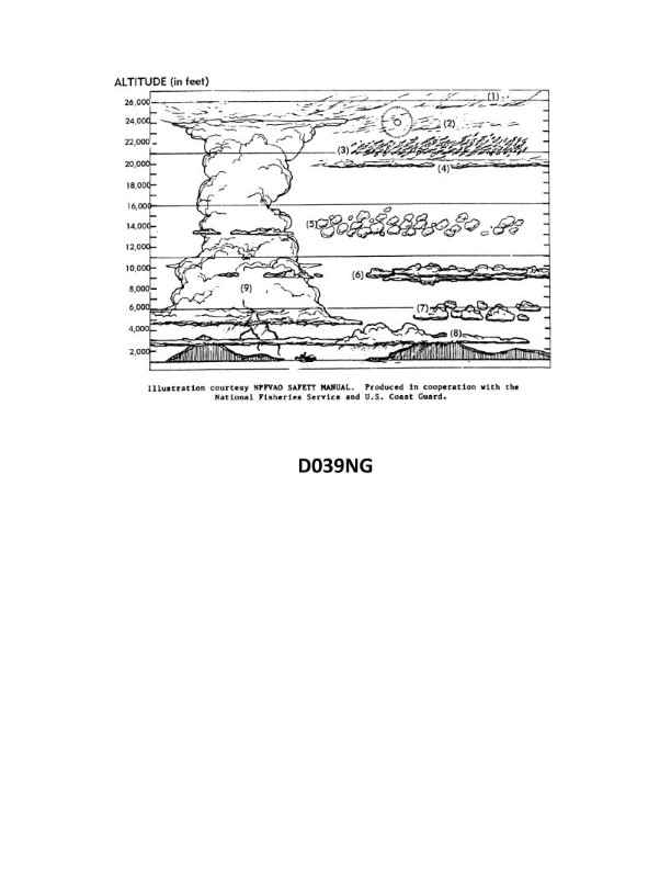
Question 1218
Question: In illustration D039NG below, what type of cloud is indicated by the number five?
A. Altocumulus
B. Cirrostratus
C. Nimbostratus
D. Cirrocumulus
The correct answer is A) Altocumulus. The image D039NG depicts different cloud types, and the cloud indicated by the number 5 is characteristic of altocumulus clouds. Altocumulus clouds are mid-level clouds that appear as patches or layers of rounded, fleecy white to gray elements. This matches the visual description provided in the image. The other answer choices do not accurately describe the cloud type shown.
Question 1219
Question: In illustration D039NG below, what type of cloud is indicated by the number four?
A. Altocumulus
B. Cumulus
C. Altostratus
D. Cirrostratus
The correct answer is C) Altostratus. The altostratus cloud type is indicated by the number 4 in the illustration D039NG. Altostratus clouds are a mid-level cloud type that appear as a grayish, sheet-like layer covering the entire sky. The other answer choices are incorrect because: A) Altocumulus are mid-level, patchy clouds; B) Cumulus are low-level, puffy clouds; and D) Cirrostratus are high-level, sheet-like clouds. The illustration clearly depicts the altostratus cloud type with the number 4.
Question 1220
Question: In illustration D039NG below, which number indicates cirrus clouds?
A. 1
B. 4
C. 5
D. 7
The correct answer is A. Number 1 in the illustration D039NG indicates cirrus clouds. Cirrus clouds are high-altitude, wispy clouds composed of ice crystals. In the illustration, the number 1 is pointing to the correct cloud type, which matches the description of cirrus clouds. The other answer choices are incorrect because numbers 4, 5, and 7 do not correspond to cirrus clouds in the image. The illustration is designed to test the candidate's ability to correctly identify different cloud types, which is an important skill for Coast Guard captains to possess when assessing weather conditions.
Question 1221
Question: In illustration D039NG below, what type of cloud is indicated by the number one?
A. Cirrus
B. Altocumulus
C. Altostratus
D. Nimbostratus
The correct answer is A) Cirrus. The cirrus cloud type is indicated by the number 1 in the illustration D039NG. Cirrus clouds are high-altitude, wispy clouds composed primarily of ice crystals. This cloud type is a key indicator for the Coast Guard Captain's License Exam, as it can signal the approach of a warm front and changing weather conditions. The other answer choices are incorrect because altocumulus (B) and altostratus (C) are mid-level cloud types, while nimbostratus (D) is a low-level, rain-producing cloud. The illustration clearly depicts the high-altitude, feathery appearance characteristic of cirrus clouds.
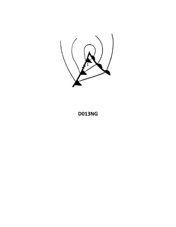
Question 1238
Question: Your vessel is enroute from Japan to Seattle and is located at position I on the weather map in illustration D013NG below. You should experience which weather condition?
A. Thundershowers
B. Overcast skies with rising temperature
C. Steady precipitation
D. Clear skies with warm temperatures
The correct answer is A) Thundershowers. Based on the weather map provided in illustration D013NG, the vessel's position at point I is located in an area with a low-pressure system, which typically brings thundershowers or unsettled weather conditions. The presence of the low-pressure system and its associated frontal activity suggests that the vessel will experience thundershowers as it travels towards Seattle from Japan. The other answer choices are incorrect because: B) Overcast skies with rising temperature and D) Clear skies with warm temperatures do not align with the weather pattern indicated by the low-pressure system on the map. C) Steady precipitation is also not the most accurate description, as thundershowers involve intermittent precipitation rather than steady rain.
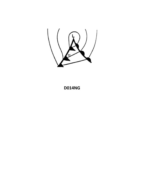
Question 1239
Question: In the Northern Hemisphere, an observer at point II in illustration D014NG below, should experience a wind shift from what direction?
A. northeast, clockwise to west-southwest
B. southwest, clockwise to northwest
C. east, counterclockwise to south-southwest
D. northeast, counterclockwise to northwest
The correct answer is B) southwest, clockwise to northwest. In the Northern Hemisphere, an observer at point II in illustration D014NG would experience a wind shift from the southwest, clockwise to the northwest. This is due to the Coriolis effect, which causes winds in the Northern Hemisphere to deflect to the right as they move. The observer at point II is positioned such that the wind direction shifts in a clockwise direction as the weather system passes by. The other options are incorrect because they do not accurately describe the wind shift direction expected in the Northern Hemisphere based on the Coriolis effect and the positioning of the observer in the illustration.
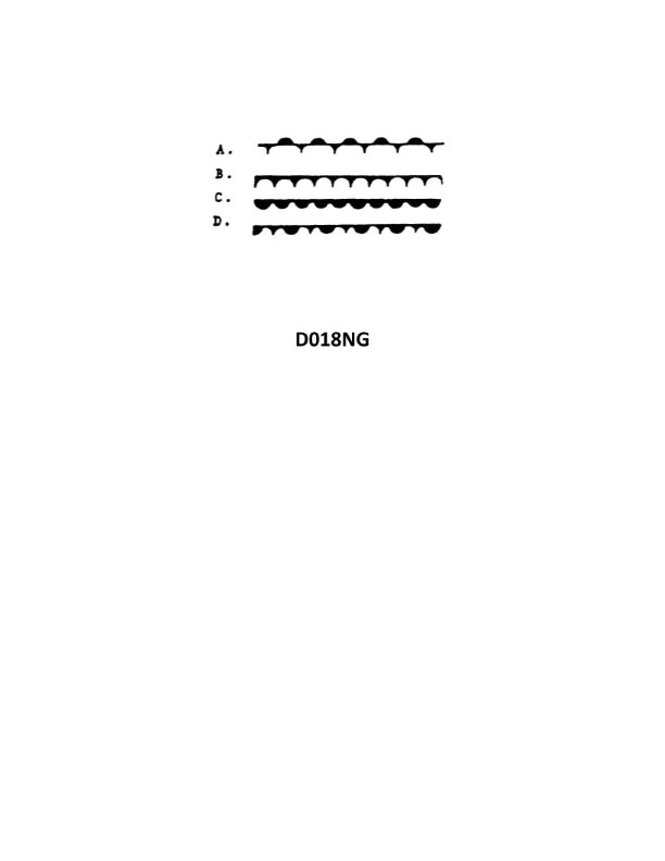
Question 1240
Question: Which of the symbols shown in illustration D018NG below represents a warm front?
A. A
B. B
C. C
D. D
The correct answer is C. The symbol representing a warm front in illustration D018NG is the semicircle symbol, which corresponds to answer choice C. Warm fronts are typically depicted using this half-circle symbol on weather maps and charts. The other symbols (A, B, and D) represent different meteorological features, such as cold fronts or low-pressure systems, but do not specifically indicate a warm front.
Question 1241
Question: Which of the symbols shown in illustration D018NG below represents an occluded front?
A. A
B. B
C. C
D. D
The correct answer is D. The symbol D in the illustration represents an occluded front, which is a type of weather front where a cold front overtakes a warm front. This is the standard symbol used on weather maps and charts to depict an occluded front, as defined by the National Weather Service and other regulatory bodies that govern maritime weather reporting. The other options (A, B, and C) represent different weather front symbols, such as a warm front or a cold front, which are distinct from the occluded front symbol shown in D.
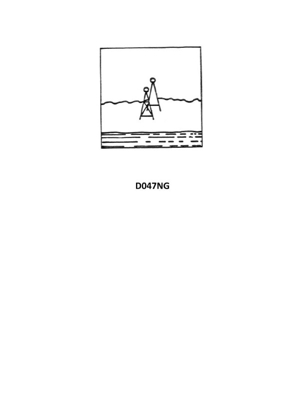
Question 1380
Question: Your vessel is entering port and you have steadied up on a range, dead ahead, in line with your keel. After a few minutes the range, still dead ahead, appears as shown in illustration D047NG below. Which action should you take?
A. Maintain heading, keeping the range dead ahead
B. Alter heading to the left
C. Increase speed
D. Alter heading to the right
The correct answer is B) Alter heading to the left. When a range appears as shown in illustration D047NG, with the range marker slightly off to the right of the vessel's centerline, it indicates that the vessel is to the right of the range. To correct this and return to the range, the vessel should alter heading to the left to bring the range marker back to the center. Maintaining the current heading (option A) or increasing speed (option C) would not resolve the vessel being off the range. Altering to the right (option D) would take the vessel further off the range.
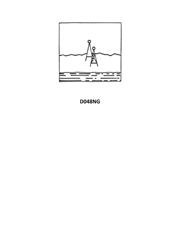
Question 1385
Question: You are inbound in a channel marked by a range. The range line is 216° T. You are steering 213° T and have the range in sight as shown in illustration D048NG below. Which action should you take?
A. Continue on the present heading until the range is in line then alter course to the right.
B. Immediately alter course to 216° T if the range is closing.
C. Immediately alter course to the right to bring the range in line.
D. Immediately alter course to the left to bring the range in line.
The correct answer is C) Immediately alter course to the right to bring the range in line. When navigating a channel marked by a range, you want to keep the range line in alignment with your course. Since you are steering 213° T and the range line is 216° T, you need to immediately alter course to the right to bring the range in line at 216° T. This will ensure you remain on the proper course through the channel. The other options are incorrect because continuing on your current heading (213° T) would cause you to drift off the range line, and altering to the left would take you further off the range line.
Question 1439
Question: You are inbound in a channel marked by a range. The range line is 040° T. You are steering 036°T. The range is in sight as shown in illustration D047NG below, and is closing. Which action should you take?
A. Continue on course until the range is closed, then alter course to the right.
B. Immediately alter course to the right to bring the range in line.
C. Continue on the present heading until the range is in line then alter course to the left.
D. Immediately alter course to 040° T.
The correct answer is A) Continue on course until the range is closed, then alter course to the right. When navigating by range, you want to keep the range line centered on your bow as you approach. By continuing on your current course of 036°T, you will gradually close the range and bring it into alignment. Once the range is in line, you can then alter course to the right to 040°T to steer along the range line. The other options are incorrect because: B) Immediately altering course to the right would take you off the range line prematurely. C) Continuing on 036°T until the range is in line, then altering to the left, would take you away from the intended range line. D) Immediately altering to 040°T would be the wrong action, as you are already close to the intended range line.
Question 1441
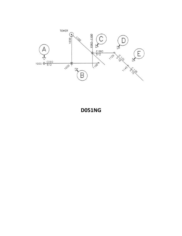
Question: In illustration D051NG below, why was the position labeled "E" plotted?
A. the vessel's position was fixed at 1145
B. the position is a running fix
C. a dead reckoning position is plotted within a half-hour of each course change
D. a dead reckoning position is plotted for each speed change
The correct answer is D) a dead reckoning position is plotted for each speed change. The key reason is that in navigation, it is standard practice to plot a dead reckoning position after each speed change, in order to accurately track the vessel's course and position. This allows the navigator to account for changes in speed and update the vessel's estimated position accordingly. Plotting a position at "E" after a speed change is the correct procedure, as outlined in the regulations and best practices for coastal navigation. The other options are incorrect because: A) the question does not specify the vessel's fixed position at 1145, B) a running fix requires taking multiple bearings or position lines, and C) while a DR position is often plotted after course changes, the question specifically asks about speed changes.
Question 1490
Question: You are inbound in a channel marked by a range. The range line is 309°T. You are steering 306°T and have the range in sight as shown in illustration D048NG below. Which action should you take?
A. Immediately alter course to 309°T if the range is closing.
B. Immediately alter course to the right to bring the range in line.
C. Immediately alter course to the left to bring the range in line.
D. Continue on the present heading until the range is in line then alter course to the right.
The correct answer is B) Immediately alter course to the right to bring the range in line. When navigating in a channel marked by a range, you should steer to keep the range line in sight and aligned with your course. Since you are currently steering 306°T and the range line is at 309°T, you need to alter course to the right to bring the range in line with your heading. This will ensure you are traveling parallel to the channel and staying on the proper course. The other options are incorrect because: A) Altering to 309°T may take you out of the channel; C) Altering to the left would take you further off course; and D) Continuing on 306°T until the range is in line would mean you are drifting to the left of the channel, which is not the proper action.
Question 1515
Question: You are outbound in a channel marked by a range astern. The range line is 273° T. You are steering 090° T and have the range in sight as shown in illustration D047NG below. What action should you take?
A. Come right to 093° T.
B. Come right to close the range then when on the range steer 093° T.
C. Come left until the range comes in line then alter course to 087° T.
D. Come left until the range comes in line than alter course to 093° T.
The correct answer is B) Come right to close the range then when on the range steer 093° T. The reasoning is that when you are outbound in a channel marked by a range astern, you should steer to keep the range lined up. Since you are currently steering 090° T and the range line is 273° T, you need to come right to close the range until it is lined up, then you can steer 093° T to maintain the range. This ensures you stay on the proper course through the channel. The other options are incorrect because A) would take you off the range, C) and D) would involve coming left instead of right to line up the range.
Question 1587
Question: Your vessel is entering port when you change course and steady up on a range with the lights in line. After a few minutes you observe the range lights as shown in illustration D047NG below. How should your heading be altered?
A. right, and when the range lights are in line again, steer to keep them dead ahead
B. left, and when the range lights are in line again, steer to keep them in line fine on the starboard bow
C. right, and when the range lights are in line again, steer to keep them in line fine on the port bow
D. left, and when the range lights are in line again, resume your original heading
The correct answer is B) left, and when the range lights are in line again, steer to keep them in line fine on the starboard bow. When the range lights are not lined up, it indicates that the vessel is off course. In this case, the illustration shows the lights are to the right of the correct alignment. To get the lights back in line, the vessel should alter course to the left. Once the lights are realigned, the vessel should then steer to keep the range lights fine on the starboard bow, meaning they appear just slightly off to the starboard side. The other options are incorrect because they either involve altering course in the wrong direction (right instead of left) or failing to steer to keep the range lights properly aligned once regained.
Question 1794
Question: In illustration D051NG below what is indicated by the position labeled "C"?
A. estimated position
B. fix
C. dead reckoning position
D. running fix
The correct answer is D) running fix. The position labeled "C" on the illustration D051NG represents a running fix, which is a position determined by taking two or more direction lines or bearings at different times and advancing the earlier line(s) to the time of the later bearing. This allows the navigator to plot the vessel's position between fixes, improving the accuracy of the vessel's track. The other answer choices are incorrect because: A) An estimated position is a position determined by dead reckoning, not by taking multiple bearings. B) A fix is a single position determined by taking a bearing or other means at a specific time. C) A dead reckoning position is a position determined solely by course and speed, without the use of navigational aids.
Question 1795
Question: In illustration D051NG below, why was the position labeled "C" plotted?
A. the vessel's course changed form due North to due East
B. the vessel's speed changed
C. running fixes are better estimates of true position than dead-reckoning positions
D. All of the above are correct
The correct answer is C) running fixes are better estimates of true position than dead-reckoning positions. The position labeled "C" on the illustration was plotted using a running fix, which provides a more accurate estimate of the vessel's true position compared to a dead-reckoning position. Running fixes incorporate multiple observations, such as bearings or ranges, to triangulate the vessel's location, whereas dead-reckoning positions are calculated based solely on the vessel's course and speed. Running fixes account for the effects of current, wind, and other factors that can cause the vessel to deviate from its expected path, making them a more reliable indicator of the vessel's actual position. The other answer choices (A and B) are incorrect because they do not directly explain why the position labeled "C" was plotted, as they do not relate to the use of running fixes versus dead-reckoning positions.
Question 1798
Question: In illustration D051NG below, why was the position labeled "D" plotted?
A. a dead reckoning position is plotted for each course change
B. the vessel's speed changed at 1125
C. a dead reckoning position is plotted within 30 minutes of a running fix
D. All of the above
The correct answer is A) a dead reckoning position is plotted for each course change. In navigation, a dead reckoning position is plotted at regular intervals, typically after each course change, to keep track of the vessel's position. This allows the navigator to monitor the vessel's progress and make any necessary adjustments to the course or speed. The position labeled "D" in the illustration D051NG was likely plotted to record the vessel's position after a course change. The other options are incorrect because they do not fully explain the purpose of plotting the position labeled "D". Option B is incorrect as it does not explain why a dead reckoning position would be plotted. Option C is incorrect as it refers to plotting a position within 30 minutes of a running fix, which is not the same as plotting a dead reckoning position after a course change.
Question 1829
Question: Your vessel has changed course and is heading 285°T, you are on the charted range and it appears as in illustration D048NG below. After several minutes the range appears as in illustration D047NG below and your heading is still 285°T. What does this indicate?
A. leeway caused by a NE'ly wind
B. course made good to the left of the DR track
C. south-setting current
D. north-setting current
The correct answer is D) north-setting current. The key evidence here is that the vessel's heading is 285°T, but the vessel has drifted to the right of the charted range, indicating a northward set to the current. A north-setting current would push the vessel to the right of the intended track, even though the vessel's heading remains 285°T. The other options are incorrect because leeway from a northeast wind would push the vessel to the left, a course made good to the left implies a southward set, and a south-setting current would push the vessel to the left, not the right as observed.
Question 1830
Question: You are outbound in a channel marked by a range astern. The range line is 309°T. You are steering 127°T and have the range in sight as shown in illustration D047NG below. What action should you take?
A. Come right to 129°T.
B. Come right to close the range then when on the range steer 129°T.
C. Come left until the range comes in line then alter course to 125°T.
D. Come left until the range comes in line then alter course to 129°T.
The correct answer is B) Come right to close the range then when on the range steer 129°T. This is the correct answer because when navigating a channel marked by a range astern, you want to steer to keep the range line centered. By coming right to close the range, you will bring the range back into alignment. Once the range is aligned, you can then alter course to the desired 129°T heading. The other options are incorrect because: A) Coming right to 129°T directly would take you off the range line. C) and D) suggest coming left, which would take you further off the range line.
Question 1831
Question: You are inbound in a channel marked by a range. The range line is 133° T. You are steering 129° T and have the range in sight as shown in illustration D048NG below. Which action should you take?
A. Immediately alter course to the left to bring the range in line.
B. Immediately alter course to 133° T if the range is closing.
C. Continue on the present heading until the range is in line then alter course to the right.
D. Immediately alter course to the right to bring the range in line.
The correct answer is D) Immediately alter course to the right to bring the range in line. The reasoning is that when running on a range, the vessel should steer to keep the range line centered and in line. Since the range line is 133°T and the vessel is steering 129°T, the vessel is to the left of the range line. To bring the range back in line, the vessel should immediately alter course to the right to 133°T. The other options are incorrect because: A) Altering to the left would take the vessel further off the range line; B) Altering to 133°T without the range closing would put the vessel off the range line; C) Continuing on the present heading would keep the vessel off the range line.
Question 1832
Question: You are entering port and have been instructed to anchor, as your berth is not yet available. You are on a SW'ly heading, preparing to drop anchor, when you observe the range lights as shown in illustration D047NG below, on your starboard beam. What action should you take?
A. ensure your ship will NOT block the channel or obstruct the range while at anchor
B. NOT drop the anchor until the lights are in line
C. drop the anchor immediately as the range lights mark an area free of obstructions
D. drop the anchor immediately as a change in the position of the range lights will be an indication of dragging anchor
The correct answer is A) ensure your ship will NOT block the channel or obstruct the range while at anchor. This is the correct answer because when anchoring, you must ensure that your vessel does not block the channel or obstruct any navigation aids, such as the range lights shown in the illustration. Blocking the channel or obstructing the range lights could create a hazardous situation for other vessels entering or leaving the port. The range lights are important navigational aids, and you must be mindful of their position and ensure your anchored vessel does not interfere with them. The other options are incorrect because: B) is incorrect as you do not need to wait for the lights to be in line before dropping anchor, as long as you ensure your vessel does not obstruct them; C) is incorrect as you should not drop the anchor immediately without first confirming it will not block the channel or obstruct the range; and D) is incorrect, as the change in the range lights' position may not necessarily indicate that your anchor is dragging.
Question 1833
Question: You are inbound in a channel marked by a range. The range line is 309°T. You are steering 306°T and have the range in sight as shown in illustration D047NG below. The range continues to open. What action should you take?
A. Alter course to the left until the range closes, then steer to the left of 306°T.
B. Alter course to the left to close the range, then alter course to 309°T.
C. Maintain course as it is normal for the range to open as you get close.
D. Alter course to the right to 309°T or more to bring the range in line.
The correct answer is A) Alter course to the left until the range closes, then steer to the left of 306°T. Explanation: 1) When the range line is 309°T and you are steering 306°T, the range line is opening, indicating that you are drifting to the right of the range. To close the range, you should alter course to the left. 2) By altering course to the left, you will bring the range line back in alignment, allowing you to then steer to the left of your original 306°T course to stay on the range. 3) Options B, C, and D are incorrect because they do not correctly address the situation of an opening range line, which requires altering course to the left to close the range. 4) Maintaining course (option C) or altering course to the right (option D) would cause you to continue drifting away from the range, which is the opposite of what is required.
Question 1835
Question: You are outbound in a channel marked by a range astern. The range line is 133°T. You are steering 315°T and have the range in sight as shown in illustration D048NG below. What action should you take?
A. Come right until the range comes in line then alter course to 313°T.
B. Come left to 313°T.
C. Come right until the range comes in line then alter course to 317°T.
D. Come left to close the range then when on the range steer 313°T.
The correct answer is D) Come left to close the range then when on the range steer 313°T. This is the correct answer because when navigating a channel marked by a range astern, you want to steer a course that keeps the range in line. Since you are steering 315°T and the range line is 133°T, coming left will bring you closer to the range line, allowing you to steer 313°T once you are on the range. The other options are incorrect because A) and C) involve altering course to the wrong heading, while B) does not actually put you on the range line.