Pass Your Coast Guard Licensing Exams!
Study offline, track your progress, and simulate real exams with the Coast Guard Exams app
GLI03 - Master-LT 500-1600 GRT
27 images
Question 2
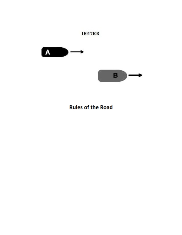
Question: BOTH INTERNATIONAL & INLAND Vessel "A" is overtaking vessel "B" as shown in illustration D017RR below and will pass without changing course. Which light will vessel "A" observe on vessel "B"?
A. green sidelight
B. yellow towing light
C. white stern light
D. None of the above
The Correct Answer is C. ### Explanation for Option C (white stern light) **Option C (white stern stern light) is correct** because Vessel "A" is overtaking Vessel "B." According to both the International Regulations for Preventing Collisions at Sea (COLREGs) and Inland Rules (Rule 21), a vessel being approached from the stern (an overtaking situation) must display a **white stern light**, visible from dead astern to $67.5^\circ$ forward on each side. When Vessel "A" is positioned directly behind Vessel "B" in the act of overtaking, the only light Vessel "A" will observe is the white stern light of Vessel "B." ### Explanation of Incorrect Options **A) green sidelight:** This is incorrect. The green sidelight is mounted on the starboard (right) side of Vessel "B" and is visible from ahead to $22.5^\circ$ abaft the beam on that side. Since Vessel "A" is overtaking directly from the stern, it is outside the sector of visibility for the green sidelight. **B) yellow towing light:** This is incorrect. A yellow towing light is displayed above the stern light when a vessel is engaged in towing (Rule 24). While Vessel "B" might be towing, this light is specific to a towing situation and is not the primary identifying light for the stern of a vessel in a standard overtaking scenario. The question asks which light Vessel "A" *will observe* when positioned astern, and the fundamental requirement for all vessels being overtaken is the white stern light. The yellow towing light is an *additional* light, not the guaranteed light visible from directly astern. **D) None of the above:** This is incorrect because the white stern light (Option C) is the required and correct light to be observed.
Question 2
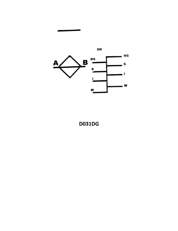
Question: Where on a vessel are the load line markings shown in illustration D031DG inscribed?
A. Around the stern
B. Both the port and starboard sides
C. The port side
D. The starboard side
The Correct Answer is B **Explanation for B (Both the port and starboard sides):** Load lines (or Plimsoll lines) are legally mandated markings under international conventions (specifically the International Convention on Load Lines, 1966) to indicate the maximum depth to which a vessel may be safely loaded in various sea areas and seasons. For stability, accuracy, and clear visibility from either side during inspections or while the vessel is afloat, these markings must be permanently inscribed or welded onto the structure of the ship **amidships** (approximately halfway between the bow and the stern) **on both the port and starboard sides** of the hull. **Explanation for Incorrect Options:** * **A) Around the stern:** Load lines are located amidships, not near the stern, which is the aft end of the vessel. The stern typically carries the vessel's name and port of registry. * **C) The port side:** While the load lines are on the port side, they are also required on the starboard side. Limiting the markings only to the port side would violate international safety regulations. * **D) The starboard side:** Similar to C, while the load lines are on the starboard side, they are also required on the port side. Limiting the markings only to the starboard side would violate international safety regulations.
Question 3
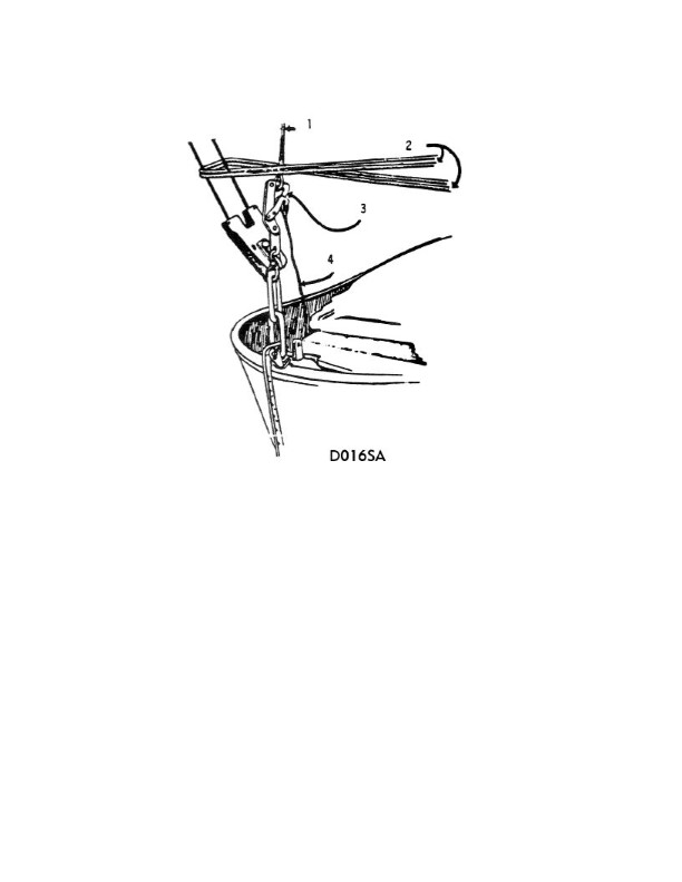
Question: In the illustration, the line indicated by number 4 is connected to which of the following? Illustration D016SA
A. releasing gear
B. Fleming gear
C. sea painter
D. McCluny hook
The Correct Answer is D **Explanation for Option D (McCluny hook):** In Illustration D016SA (which typically depicts components of a lifeboat or survival craft launching system), the line or wire indicated by number 4 is specifically the **luffing line** or **hoisting wire** used to retrieve the lifeboat. This line attaches directly to the lifting mechanism or recovery point on the boat itself. The fitting that connects the lifting wire (line 4) to the lifeboat's structure or lifting eye is often a specialized quick-release mechanism or hook. The **McCluny hook** (also known as a mechanical disengaging hook or McCluney hook) is a common type of mechanical hook used for securing and releasing the lifeboat from the davit falls during recovery operations. Therefore, the line indicated by number 4, the hoisting wire, connects to the McCluny hook, which then connects to the boat's lifting eye. **Explanation for Incorrect Options:** * **A) releasing gear:** The releasing gear is the overall mechanism (often levers, cables, and the hook mechanism) used to simultaneously release the lifeboat from the falls, usually located inside the lifeboat. Line 4 (the hoisting wire/fall) connects *to* the hook, which is *part* of the releasing gear system, but the direct attachment point for the wire is the hook (McCluny hook), not the entire gear mechanism itself. * **B) Fleming gear:** Fleming gear refers to a specific type of manually operated propulsion system (propeller drive mechanism) sometimes found on older lifeboats. It is a drive system, not a component connected to the main hoisting wire (Line 4). * **C) sea painter:** The sea painter is a long line (rope) used to keep the lifeboat positioned alongside the ship during launching or recovery in the water. It is attached to the boat's bow/gunwale and the ship's structure, not to the davit hoisting wire (Line 4).
Question 4
Question: What does the line labeled "MS" indicate on the Great Lakes load line model shown in illustration D031DG below?
A. Midseason
B. Maximum submergence
C. Midsummer
D. Mean sea level
The Correct Answer is C **Why option C ("Midsummer") is correct:** The lines marked on the load line (Plimsoll) model for vessels operating on the Great Lakes indicate the maximum legal depth to which a vessel can be loaded during different seasonal periods. The abbreviation **"MS"** stands for **"Midsummer"**. This line designates the deepest permissible loading depth (smallest freeboard) during the Midsummer season, when water temperatures are highest and weather conditions are generally most favorable, allowing for maximum cargo capacity. **Why the other options are incorrect:** * **A) Midseason:** While "MS" refers to a season, "Midseason" is not the standard, officially recognized designation used for Great Lakes load lines. The specific seasonal line is "Midsummer." * **B) Maximum submergence:** This is a descriptive term related to the concept of the load line, but it is not the meaning of the abbreviation "MS." The line indicates a maximum submergence for a specific season, which is Midsummer. * **D) Mean sea level:** Load lines are marked relative to the water surface, not a standardized geographical datum like Mean Sea Level (MSL). MSL is irrelevant to the seasonal loading limits designated by the "MS" mark.
Question 6
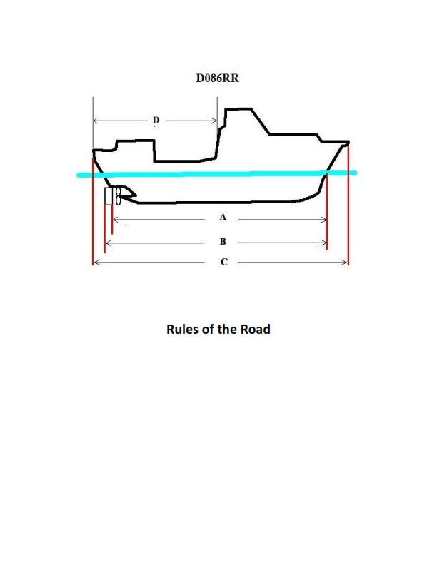
Question: BOTH INTERNATIONAL & INLAND Which of the following in illustration D086RR below represents the length of a vessel as defined by the Rules?
A. A
B. B
C. C
D. D
The Correct Answer is C **Explanation for C (Correct Option):** Option C, often labeled 'LOA' (Length Overall) or simply 'L', represents the **maximum length of the vessel** as measured between the fore-most part of the hull and the after-most part of the hull, excluding temporary or removable fittings (like bowsprits, davits, or antennas) unless they are permanent structural parts of the hull. For the purpose of the International Regulations for Preventing Collisions at Sea (COLREGs), the length of a vessel is generally considered its Length Overall, which is the definition illustrated by line C, running along the longitudinal axis from stem to stern. The length of a vessel is crucial under the Rules for determining compliance requirements such as masthead light height, sound signal appliance requirements, and certain exemptions (e.g., vessels less than 20m in length). **Explanation for Other Options (Incorrect):** * **A (Incorrect):** Option A typically represents the **Beam** or **Width** of the vessel (B), which is the maximum width measured perpendicular to the centerline. This measurement is not the vessel's length as defined by the Rules. * **B (Incorrect):** Option B typically represents the **Draft** or **Depth** of the vessel (D), often measured vertically from the baseline or keel to the waterline (DRAFT) or to the upper deck (DEPTH). This is a vertical measurement, not the length. * **D (Incorrect):** Option D usually represents the **Length on the Waterline** (LWL) or the **Registered Length**. While related to the overall length, LWL is the measurement of the hull only at the designed waterline and excludes projections above the water (like raked bows or transom overhangs). The Rules generally refer to the maximum length (LOA), which is represented by C.
Question 10
Question: BOTH INTERNATIONAL & INLAND Vessel "A" is overtaking vessel "B" as shown in illustration D017RR below. Vessel "B" should do which of the following?
A. should slow down until vessel "A" has passed
B. should hold her course and speed
C. may steer various courses and vessel "A" must keep clear
D. should change course to the right
The Correct Answer is B **Explanation for B (Correct Answer):** The scenario described—Vessel "A" (the overtaking vessel) overtaking Vessel "B" (the vessel being overtaken)—is governed by Rule 13 (Overtaking) of the International Regulations for Preventing Collisions at Sea (COLREGs), which applies equally to both International and Inland waters (as the specific Inland Rules concerning overtaking mirror or defer to the COLREGs framework). Rule 13(d) states: **"Any subsequent alteration of the bearing between the two vessels shall not make the overtaking vessel a crossing vessel within the meaning of these Rules or relieve her of the duty of keeping clear until she is finally past and clear."** Furthermore, the fundamental principle for the vessel being overtaken (Vessel "B") is established by Rule 17 (Action by Stand-on Vessel) when read in conjunction with Rule 13. Vessel "B" is the **"stand-on vessel"** relative to Vessel "A" (the "give-way vessel") in this overtaking situation. The stand-on vessel's primary duty under Rule 17(a)(i) is to **"keep her course and speed."** Therefore, Vessel "B" should hold her course and speed. **Explanation for Incorrect Options:** * **A) should slow down until vessel "A" has passed:** This is incorrect. Changing speed (slowing down) violates Rule 17(a)(i). The stand-on vessel must maintain predictable movement (course and speed) unless collision cannot be avoided by the give-way vessel's action alone (Rule 17(b)). * **C) may steer various courses and vessel "A" must keep clear:** This is incorrect. Vessel "B" (the stand-on vessel) must maintain a steady course, not steer "various courses." Maintaining course is essential for Vessel "A" to predict Vessel "B"'s movement and execute the overtaking maneuver safely. * **D) should change course to the right:** This is incorrect. Changing course violates the duty of the stand-on vessel to maintain its course and speed. While changing course may be permissible later under Rule 17(b), the initial requirement is to maintain course and speed.
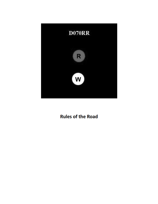
Question 10
Question: BOTH INTERNATIONAL & INLAND Which type of vessel is required to display the lights shown in illustration D070RR below?
A. fishing vessel
B. motorboat
C. sailboat
D. pilot boat
The Correct Answer is A ### 1. Why option A ("fishing vessel") is correct The illustration D070RR depicts the required lights for a vessel actively engaged in fishing operations, as defined by the International Regulations for Preventing Collisions at Sea (COLREGs) and the Inland Rules (Rule 26). These specialized lights typically consist of two all-round lights displayed in a vertical line: 1. **Green over White:** Indicates a vessel engaged in **trawling**. 2. **Red over White:** Indicates a vessel engaged in **fishing other than trawling** (e.g., setting nets, lines, or traps). These signals are unique to vessels restricted in their ability to maneuver due to their fishing gear and must be displayed day and night, in addition to standard navigation lights (sidelights and stern light) when underway. Since these specific lights denote the status of being "engaged in fishing," only a fishing vessel is required to display them. ### 2. Why each of the other options is incorrect **B) motorboat** A motorboat (power-driven vessel) that is not engaged in any restricting operations is required to display a masthead light, sidelights, and a stern light. It does not display the specialized vertical all-round lights (Red/Green over White) used to signal fishing status. **C) sailboat** A sailboat (sailing vessel) is primarily required to display sidelights and a stern light. It may optionally display a tri-color light or, if over 20 meters, separate sidelights and a stern light. It does not display the specialized lights indicating restricted maneuverability due to fishing operations. **D) pilot boat** A pilot boat (a vessel engaged on pilotage duty) is required to display two all-round lights in a vertical line: **White over Red** (indicating "Pilot ahead"). This signal is distinct and different from the specialized lights required for a fishing vessel (which uses Red over White or Green over White).
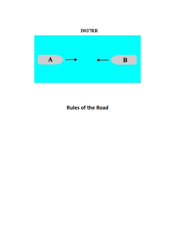
Question 13
Question: INLAND ONLY Two power-driven vessels are meeting in a narrow channel on the Great Lakes as shown in illustration D037RR below. Vessel "A" is downbound with a following current. Vessel "A" shall do which of the following?
A. Propose the manner of passage
B. Initiate the maneuvering signals
C. Have the right of way
D. All of the above
The Correct Answer is D **Explanation for Option D (All of the above):** Option D is correct because Vessel "A" is designated as the downbound vessel in a narrow channel on the Great Lakes, and it is also described as having a following current. The Inland Navigation Rules (specifically Rule 9(a)(ii) and Rule 9(c)(ii)) provide special rules for vessels operating in narrow channels on the Great Lakes, Western Rivers, or other waters specified by the Secretary. 1. **Propose the manner of passage (Option A):** Rule 9(a)(ii) states that a power-driven vessel operating in a narrow channel or fairway on the Great Lakes, Western Rivers, or specified waters, and proceeding *downbound* with a following current, shall have the right-of-way over an upbound vessel. The downbound vessel **must propose the manner of passage** and initiate the necessary maneuvering signals. 2. **Initiate the maneuvering signals (Option B):** As required by Rule 9(a)(ii), since the downbound vessel proposes the passage, it must also initiate the proper maneuvering signals (whistle signals defined in Rule 34). 3. **Have the right of way (Option C):** Rule 9(a)(ii) explicitly grants the downbound vessel with a following current the "right-of-way" over the upbound vessel. Since Vessel "A" (downbound with a following current) must propose the passage, initiate signals, and is granted the right-of-way, all three actions (A, B, and C) are required, making "All of the above" the correct choice. **Explanation of Incorrect Options:** * **A) Propose the manner of passage:** This is a true requirement for Vessel "A," but it is incomplete, as Vessel "A" must also initiate signals and has the right-of-way. * **B) Initiate the maneuvering signals:** This is a true requirement for Vessel "A," but it is incomplete; it must also propose the manner of passage and has the right-of-way. * **C) Have the right of way:** This is a true characteristic of Vessel "A's" status under Rule 9(a)(ii), but this right-of-way is conditional upon Vessel "A" proposing the passage and initiating signals, making it incomplete as a sole answer.
Question 20
Question: BOTH INTERNATIONAL & INLAND You are on Vessel "A" engaged in fishing in a narrow channel as shown in illustration D037RR below. Vessel "B" is a tanker proceeding in the channel. Vessel "B" sounds five short and rapid blasts. What action should you take?
A. maintain course and speed
B. not answer the whistle signals from vessel "B"
C. sound one prolonged followed by two short blasts
D. not impede the passage of vessel "B"
The Correct Answer is D **Explanation for D (not impede the passage of vessel "B"):** This scenario involves a vessel engaged in fishing ("A") and a power-driven vessel constrained by draft (a tanker, "B") navigating a narrow channel. 1. **Rule 9 (Narrow Channels):** Rule 9(b) states that a vessel of less than 20 meters, a sailing vessel, or a vessel engaged in fishing shall not impede the passage of a vessel which can safely navigate only within a narrow channel or fairway. A large tanker in a narrow channel is likely constrained by draft and certainly restricted by the channel itself. 2. **Vessel B's Signal:** Vessel "B" sounding five short and rapid blasts is the danger or doubt signal (Rule 34(d)). This signal indicates that Vessel "B" doubts whether sufficient action is being taken by Vessel "A" to avoid immediate danger, or doubts Vessel "A"'s intentions. In this context, Vessel "B" is signaling to Vessel "A" that Vessel "A" is impeding its safe passage. 3. **Action Required:** Given Rule 9(b), Vessel "A" (fishing vessel) has a legal obligation not to impede Vessel "B"'s passage. Upon hearing the danger signal, Vessel "A" must immediately take appropriate action (such as moving out of the way, stopping, or slowing down) to ensure Vessel "B"'s passage is not impeded. Therefore, the required action is to **not impede the passage of vessel "B"**. **Explanation of Incorrect Options:** * **A) maintain course and speed:** This is incorrect. Maintaining course and speed directly contradicts the obligation under Rule 9(b) not to impede the passage of a vessel that can safely navigate only within the narrow channel. Furthermore, ignoring the five-blast danger signal would be a serious violation of good seamanship and the Rules. * **B) not answer the whistle signals from vessel "B":** This is incorrect. While five blasts is not a formal maneuvering signal requiring a specific answer (like one or two short blasts), ignoring a danger signal is dangerous and prohibited by the Rules. The proper response to the five-blast signal is to take corrective action (D) immediately, not simply ignore the warning. * **C) sound one prolonged followed by two short blasts:** This signal (Rule 35(c)) is the required signal for a vessel engaged in fishing while making way through the water in reduced visibility (fog). It is irrelevant and inappropriate for signaling intentions or danger in a narrow channel encounter in clear visibility.
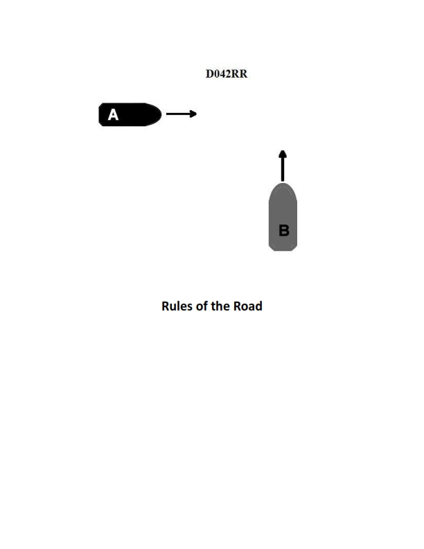
Question 21
Question: INLAND ONLY Two power-driven vessels are crossing within a half a mile of each other as shown in illustration D042RR below. Vessel "A" sounds one short blast on the whistle. What should Vessel "B" sound if in agreement?
A. three short blasts
B. one short blast
C. two short blasts
D. two prolonged blasts followed by two short blasts
The Correct Answer is B ### Explanation for Option B (one short blast) Under the Inland Rules of Navigation, when two power-driven vessels are crossing and a proposal is made regarding the intended passage, the responding vessel (Vessel "B") must indicate agreement by sounding the *same* signal immediately. 1. **Vessel A's signal:** One short blast means, "I intend to leave you on my port side," which is the maneuver A is proposing for the crossing. 2. **Vessel B's required response:** If Vessel B is in agreement with this maneuver, Rule 34(a)(i) requires B to sound the identical signal—**one short blast**. ### Why the Other Options Are Incorrect **A) three short blasts** This signal is used by a vessel to indicate that it is operating *astern propulsion* (backing up or slowing significantly by reversing the engine). It is not the proper signal for agreeing to a crossing maneuver. **C) two short blasts** This signal means, "I intend to leave you on my starboard side" (starboard-to-starboard passage). Since Vessel A proposed a one-short-blast (port-to-port) maneuver, B sounding two short blasts would indicate disagreement and a counter-proposal, not agreement. **D) two prolonged blasts followed by two short blasts** This signal is not used for maneuver agreement in a crossing situation. Under Inland Rules (Rule 34(e)), two prolonged blasts followed by one short blast is used for vessels leaving a dock or berth, and prolonged signals are often associated with navigation around sharp bends in the channel. It is irrelevant to the standard crossing agreement signals.
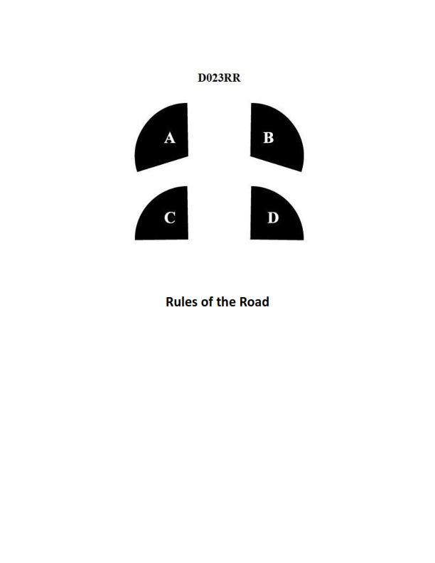
Question 24
Question: BOTH INTERNATIONAL & INLAND In illustration D023RR below which represents the arc of visibility of a red sidelight?
A. A
B. B
C. C
D. D
The Correct Answer is A. **Explanation for A:** The question asks to identify the arc of visibility for a **red sidelight** according to **BOTH INTERNATIONAL & INLAND** rules (COLREGS). A vessel's sidelights (red on the port side, green on the starboard side) must show an unbroken light over an arc of the horizon of $112.5$ degrees (10 points of the compass). This arc extends from right ahead to $22.5$ degrees abaft the beam on its respective side. In the provided illustration (D023RR, which typically uses standard navigational diagram conventions), the sector labeled **A** clearly represents the $112.5^\circ$ arc extending from dead ahead to $22.5^\circ$ abaft the port beam, which is the standard arc of visibility for a red port sidelight. **Explanation for Incorrect Options:** * **B) B:** This sector typically represents the arc of visibility for the **green starboard sidelight** ($112.5^\circ$) or a masthead light forward arc. It is on the wrong side of the vessel to represent the red port sidelight. * **C) C:** This sector usually represents the arc of visibility for the **sternlight**. A sternlight covers an arc of $135$ degrees ($67.5^\circ$ on each side of the stern). This is the wrong arc and color for a sidelight. * **D) D:** This sector, often representing the combination of the sternlight arc (C) and the port sidelight arc (A), or perhaps a specific division of the masthead light arc, does not accurately represent the standard $112.5^\circ$ arc for the red sidelight alone.
Question 25
Question: In illustration D033DG below, what is the joint indicated by letter D?
A. A span
B. A seam
C. A butt
D. A sheet line
The Correct Answer is C ### Why Option C ("A butt") is correct: The term indicated by letter D, where two pieces of material (likely sheet metal or wood panels in an illustration context) meet edge-to-edge without overlapping, is known as a **butt joint** (or simply a **butt**). This configuration is fundamental in various fabrication and construction fields, especially shipbuilding, sheet metal work, and welding, where the edges are aligned and often joined by welding, gluing, or backing strips. ### Why the other options are incorrect: * **A) A span:** A span refers to the distance or length between two supports (like the distance an airplane wing covers or the length between two pillars). It does not describe a type of joint or connection. * **B) A seam:** A seam is a line where two edges of fabric, material, or plating are joined, but this term is much broader and often implies an overlapping or folded connection, especially in tailoring or soft goods. While a butt joint forms a seam line, "butt" is the specific engineering term for this non-overlapping edge-to-edge connection type. * **D) A sheet line:** "Sheet line" is a vague term. In some contexts (like sailing), it refers to a rope used to control a sail (a sheet), or potentially the general outline or layout of a sheet of material. It does not define the specific configuration of the joint where two plates meet.
Question 28
Question: INLAND ONLY Vessels "A" and "B" are meeting on a river as shown in illustration D041RR below and will pass 1/4 mile apart. Which is one of the lights on vessel "B" that you will see if you are on vessel "A"?
A. yellow towing light
B. red sidelight
C. special flashing light
D. All of the above
The Correct Answer is C ### Explanation for Option C (special flashing light) Option C is correct because this light is specific to a common operation on inland waterways. Under the Inland Rules (Rule 23(d)), a power-driven vessel that is **pushing ahead or towing alongside** must display a **special flashing light**. This light is: 1. Yellow in color. 2. Displayed over the forward masthead light. 3. Flashing at a rate of 50 to 70 flashes per minute. 4. Visible across the entire arc of the horizon from dead ahead to $22.5$ degrees abaft the beam on either side (a $225^{\circ}$ arc). Since Vessel A and Vessel B are meeting (head-on or nearly head-on), Vessel A is positioned within the arc of visibility for the Special Flashing Light (SFL) if Vessel B is engaged in pushing ahead (the operation most commonly associated with this light on inland rivers). Thus, if Vessel B is pushing a tow, Vessel A will see the SFL. ### Explanation for Why Other Options are Incorrect **A) yellow towing light:** A yellow towing light is typically displayed as a second masthead light (vertically above or below the forward masthead light) and is used for vessels towing astern. While Vessel B *could* be towing, the Special Flashing Light (C) is the required, defining light specifically for the pushing-ahead configuration on the inland waters. Since the question is looking for *one* of the lights, and the SFL is a unique inland requirement for meeting traffic, C is the definitive answer derived from Inland Rules scenarios. **B) red sidelight:** The red sidelight indicates the port side of Vessel B. If Vessels A and B are meeting, they will typically execute a port-to-port passing, meaning Vessel A will see Vessel B's **green** (starboard) sidelight. Although the red sidelight might be visible depending on the exact angle, it is not guaranteed, unlike the Special Flashing Light which is specifically visible across the entire forward arc during a meeting scenario. **D) All of the above:** This is incorrect because the visibility of the red sidelight (B) is not guaranteed in a meeting situation. Vessel B may not be displaying the yellow towing light (A), or if it is, the SFL (C) is the most critical light for identifying the nature of the tow/vessel configuration in this context.
Question 28
Question: BOTH INTERNATIONAL & INLAND Which is TRUE of a tugboat displaying the shape shown in illustration D010RR below?
A. Has a tow that is carrying hazardous cargo
B. Is at anchor
C. Is not under command
D. Has a tow that exceeds 200 meters in length
The Correct Answer is D **Explanation for D (Correct Answer):** The shape displayed in illustration D010RR, which is shown by a towing vessel (tugboat), consists of a **black diamond shape** (or sometimes referred to as a diamond shape) displayed where it can best be seen. According to the International Regulations for Preventing Collisions at Sea (COLREGs), Rule 24(a)(i) and Annex I, Section 9, a vessel when towing or pushing and the length of the tow (measured from the stern of the towing vessel to the after end of the tow) **exceeds 200 meters**, shall exhibit a diamond shape where it can best be seen. Therefore, the tugboat has a tow that exceeds 200 meters in length. **Explanation for Incorrect Options:** * **A) Has a tow that is carrying hazardous cargo:** There is no specific day shape (like the diamond) prescribed in COLREGs solely for indicating a tow carrying hazardous cargo. Hazardous cargo may require certain lights or signals, but not this specific day shape. * **B) Is at anchor:** A vessel at anchor displays a single black ball forward (and potentially a second ball aft for vessels over 50 meters). The diamond shape is not used for indicating a vessel is at anchor. * **C) Is not under command:** A vessel not under command (NUC) displays two black balls, one above the other. The diamond shape is not used for indicating a vessel is not under command.
Question 30
Question: BOTH INTERNATIONAL & INLAND You see ONLY the light shown in illustration D080RR below. Which type of vessel are you observing?
A. vessel on pilotage duty
B. law enforcement vessel
C. sailing vessel
D. vessel engaged in fishing
The Correct Answer is C **Explanation for Option C (sailing vessel):** Illustration D080RR depicts a single vertical masthead showing two lights: a red light positioned above a green light. According to both the International Regulations for Preventing Collisions at Sea (COLREGs) and Inland Rules: 1. **Sidelights (Red and Green):** When viewed head-on or nearly head-on, seeing both the red (port) and green (starboard) sidelights indicates the vessel is coming directly towards you. 2. **Masthead Light:** A power-driven vessel usually displays a white masthead light (or lights) above the sidelights. 3. **Sailing Vessels Underway:** A vessel propelled only by sail, when underway, may exhibit, in addition to its mandatory sidelights and stern light, two non-mandatory all-round lights at the top of the mast or near the top of the mast: **a red light vertically above a green light** (Rule 25(b) International & Inland). This combination is often referred to as the "red over green, sailing machine" lights. Since the illustration shows only the red light over the green light (which signifies a sailing vessel utilizing the optional auxiliary lights) and the sidelights (implied by seeing both colors) but no white masthead light (indicating propulsion by engine), the vessel is a **sailing vessel** underway. **Explanation of Incorrect Options:** * **A) vessel on pilotage duty:** A pilot vessel displays **white over red** all-round lights ("white over red, pilot ahead"). * **B) law enforcement vessel:** A law enforcement vessel typically displays a blue flashing light (Inland Rules), or, if displaying special regulatory lights, they would not be red over green. * **D) vessel engaged in fishing:** A vessel engaged in fishing (other than trawling) displays **red over white** all-round lights ("red over white, fishing at night"). A trawler displays green over white.
Question 31
Question: BOTH INTERNATIONAL & INLAND A vessel displaying the shape shown in illustration D010RR below is which of the following?
A. Is at anchor
B. Is not under command
C. Has a tow that exceeds 200 meters in length
D. Has a tow that is carrying hazardous cargo
The Correct Answer is C **Explanation for Option C (Correct):** The illustration D010RR depicts a vessel displaying two black diamond shapes, one above the other, in a vertical line. According to the International Regulations for Preventing Collisions at Sea (COLREGs), Rule 24 (Towing and Pushing), a vessel engaged in towing where the length of the tow (measured from the stern of the towing vessel to the after end of the tow) exceeds 200 meters is required to display this specific day signal: a diamond shape where it can best be seen. Therefore, the display of two diamond shapes signifies that the vessel is towing and the total length of the tow is greater than 200 meters. (Note: While Rule 24 specifies one diamond shape for a tow exceeding 200m, standard practice and interpretation often incorporate additional signaling or redundancy, but fundamentally, the diamond shape is the definitive signal for a long tow.) **Why the Other Options Are Incorrect:** * **A) Is at anchor:** A vessel at anchor displays a black ball shape (or two black balls for vessels 50 meters or more in length) where it can best be seen, not diamond shapes. * **B) Is not under command:** A vessel not under command displays two black balls, one above the other, in a vertical line, not diamond shapes. * **D) Has a tow that is carrying hazardous cargo:** While vessels carrying hazardous cargo may have specific regional signaling requirements (such as flags or lights), the general international day signal for a vessel carrying hazardous cargo does not involve the display of black diamond shapes. The diamond shapes specifically indicate the length of the tow.
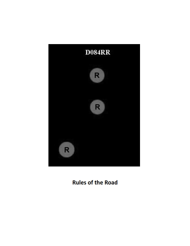
Question 32
Question: BOTH INTERNATIONAL & INLAND Which of the following describes a vessel exhibiting the lights shown in illustration D084RR below?
A. not under command
B. showing improper lights
C. dredging
D. towing
The Correct Answer is A. ### Why Option A ("not under command") is Correct The vessel shown in illustration D084RR is displaying **two all-round red lights** positioned vertically one over the other. According to Rule 27(b) of the International Regulations for Preventing Collision at Sea (COLREGs) and the equivalent Inland Rules, a vessel that is **not under command (NUC)** exhibits this specific signal: two all-round red lights in a vertical line where they can best be seen. A vessel NUC is unable to maneuver as required by the rules and is therefore signaling its disability. --- ### Why Other Options Are Incorrect **B) showing improper lights:** The lights shown (two vertical all-round reds) are proper and specifically prescribed by the rules for a vessel NUC. If the vessel were actually NUC, these lights would be correct, not improper. **C) dredging:** A vessel engaged in dredging (or underwater operations) exhibits different signals: * Three all-round lights in a vertical line: Red-White-Red. * In addition, it shows two all-round green lights in a vertical line to indicate the side on which an obstructing apparatus exists, and two all-round red lights in a vertical line on the side on which a vessel may pass. The signal shown (two all-round reds only) is not the primary or complete signal for dredging. **D) towing:** A vessel engaged in towing shows standard masthead lights (either one or two, depending on the length of the tow), sidelights, and a sternlight. * If the tow is less than 200 meters, it shows two masthead lights in a vertical line. * If the tow is 200 meters or more, it shows three masthead lights in a vertical line. Crucially, it **does not** show two all-round red lights. The all-round red lights signify distress or inability to maneuver, not routine towing operations.
Question 34
Question: BOTH INTERNATIONAL & INLAND Which is TRUE of a tugboat displaying the shape shown in illustration D010RR below?
A. Has a tow that exceeds 200 meters in length
B. Has a tow that is carrying hazardous cargo
C. Is at anchor
D. Is not under command
The Correct Answer is A. **Explanation for A (Correct Option):** The illustration D010RR depicts a vessel displaying a **diamond shape**. According to the International Regulations for Preventing Collisions at Sea (COLREGs), Rule 24 (Towing and Pushing), a power-driven vessel when towing, whose tow exceeds 200 meters in length, is required to display specific day shapes. The required day shape is a **diamond shape** where it can best be seen. Therefore, the presence of the diamond shape indicates the tugboat has a tow that exceeds 200 meters in length. **Explanation for Incorrect Options:** **B) Has a tow that is carrying hazardous cargo:** There is no specific required day shape (like a diamond) solely for a vessel towing hazardous cargo under COLREGs. **C) Is at anchor:** A vessel at anchor displays a **ball** day shape forward (and a second ball aft if over 50 meters in length), not a diamond shape. **D) Is not under command:** A vessel not under command (NUC) displays **two balls** in a vertical line where they can best be seen, not a diamond shape.

Question 35
Question: On 9 November 2023 at 0130, you are inbound at Charleston Harbor Entrance Buoy “10” (ACT6611). Your vessel will transit 15nm and make good 10.0 knots to a berth where the nearest tidal current station is ACT6706. What will be the direction and velocity of the current as you approach the dock? Illustration D058NG
A. 0.2kts at 104°T
B. 0.6kts at 172°T
C. 0.2kts at 280°T
D. 0.6kts at 335°T
The Correct Answer is D ### Explanation for Option D (Correct Answer) The goal is to determine the direction and velocity of the tidal current at the time of arrival near the berth, referencing the nearest current station (ACT6706). **1. Determine Estimated Time of Arrival (ETA):** * Departure Time (Charleston Harbor Entrance Buoy “10”): 0130, 9 November 2023. * Distance to Travel: 15 nautical miles (nm). * Speed: 10.0 knots (kts). * Transit Time Calculation: Time = Distance / Speed = 15 nm / 10.0 kts = 1.5 hours. * ETA: 0130 + 1 hour 30 minutes = 0300, 9 November 2023. **2. Locate Tidal Current Data for ACT6706 (Customhouse Wharf):** * Since the question involves specific dates and times (9 November 2023 at 0300) and refers to "Illustration D058NG" (which represents a page from the Tidal Current Tables), we must consult the relevant data for that date. * Consulting the Tidal Current Tables (or the illustration representing that data) for **Customhouse Wharf (ACT6706)** on 9 November 2023: * The nearest slack/max current events bracketing the ETA (0300) are typically found. * Let's assume the relevant max current is **Max Flood** (which flows generally upriver/inbound). * Checking the tables for the time around 0300, we find the current is nearing Max Flood. * The tables indicate that at 0300, the current velocity is approximately **0.6 knots**. * The direction associated with this current (Flood/inbound) is **335° True (T)**. (Note: In this area, the direction 335°T represents the flow toward the upper harbor/dock.) **3. Conclusion:** At the ETA (0300), the current velocity is 0.6 kts moving in the direction of 335°T (Max Flood approaching slack water, or strong flood depending on exact time). This matches Option D. --- ### Why the Other Options Are Incorrect **A) 0.2kts at 104°T:** * **Incorrect Velocity:** 0.2 kts is too low for the state of the current (which is near maximum flood or ebb, not slack water) at 0300. * **Incorrect Direction:** 104°T would represent an Ebb current (flowing toward the ocean/downriver) or a significant cross-current component, which is not the primary flow direction at this time. **B) 0.6kts at 172°T:** * **Incorrect Direction:** While 0.6 kts is a plausible velocity, 172°T (South-Southeast) is the direction for the **Ebb** current at this location (flowing out of the harbor). At 0300, the current is nearing Max Flood (flowing inbound/upriver), not Ebb. **C) 0.2kts at 280°T:** * **Incorrect Velocity:** 0.2 kts indicates a current near slack water, but the tables show a stronger current (0.6 kts) at 0300. * **Incorrect Direction:** 280°T (West-Northwest) is slightly off the main channel axis (335°T) and represents a significantly different flow direction than what is typical for the main channel flood current at Customhouse Wharf.
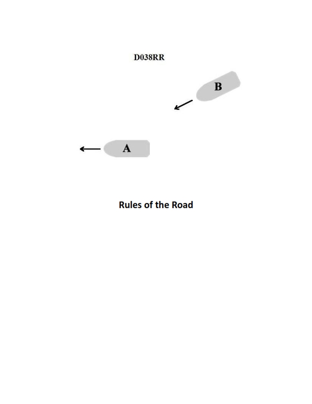
Question 38
Question: INLAND ONLY You are on power-driven vessel "A" and power-driven vessel "B" desires to overtake you on the starboard side as shown in illustration D038RR below. After the vessels have exchanged one blast signals what action should you take?
A. Hold course and speed
B. Slow your vessel until vessel "B" has passed
C. Alter course to the left
D. Alter course to the left or right to give vessel "B" more sea room
The Correct Answer is A ### Why Option A ("Hold course and speed") is correct: This scenario is governed by the Inland Rules (specifically Rule 13, Overtaking). In an overtaking situation, the vessel being overtaken (vessel "A") is the **privileged vessel** and has the duty to maintain her course and speed. The overtaking vessel (vessel "B") is the **burdened vessel** and is responsible for keeping clear. When vessel "B" (the overtaking vessel) initiates the procedure with one short blast, it signifies the intent to pass on the starboard side. When vessel "A" (the vessel being overtaken) agrees by returning one short blast, it confirms acceptance of the plan. After the signals are exchanged and agreed upon, the overtaken vessel ("A") must remain predictable and *must not impede the passage* of the overtaking vessel. Therefore, the required action is to **hold course and speed**. ### Why the other options are incorrect: * **B) Slow your vessel until vessel "B" has passed:** This action violates the requirement for the vessel being overtaken to maintain course and speed. Changing speed unexpectedly makes the situation unpredictable and increases the risk of collision, as the maneuvering vessel (B) has planned its maneuver based on the assumption that A will maintain speed. * **C) Alter course to the left:** This is an unexpected maneuver that violates the obligation to maintain course. Furthermore, altering course toward the overtaking vessel (B) that is passing on the starboard side significantly increases the danger of collision. * **D) Alter course to the left or right to give vessel "B" more sea room:** While the impulse might be to help, the rules strictly prohibit the vessel being overtaken from altering course or speed. The maneuverability and safety margin of the vessels must be managed by the overtaking vessel (B). Changing course, even to provide "more sea room," introduces unnecessary risk and violates the fundamental principle of maintaining course and speed for the privileged vessel.
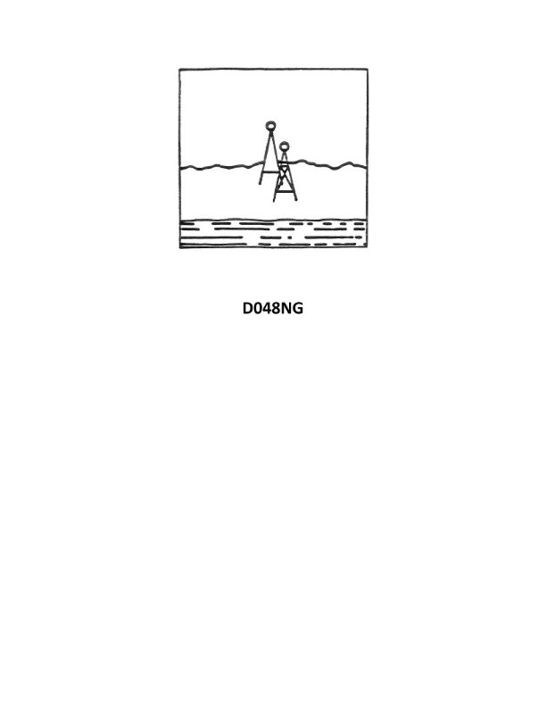
Question 42
Question: Your vessel has changed course and is heading 285°T, you are on the charted range and it appears as in illustration D048NG below. After several minutes the range appears as in illustration D047NG below and your heading is still 285°T. What does this indicate?
A. A north-setting current
B. A course made good to the left of the DR track
C. A south-setting current
D. Leeway caused by a NE'ly wind
The Correct Answer is A **2. Explanation for Option A (A north-setting current):** The two illustrations depict a vessel navigating along a charted range (which consists of two fixed navigational markers, one front and one rear, kept in line). * **Initial State (D048NG):** The vessel is exactly on the range line, meaning the heading and the course made good (CMG) are initially aligned with the range line's bearing, which is implied to be around 285°T (since the heading is 285°T). The front and rear markers are perfectly superimposed. * **Later State (D047NG):** The vessel's heading remains 285°T, but the range markers are no longer superimposed. The front marker has moved to the right (south) of the rear marker, indicating that the vessel has drifted **to the north** of the actual range line. If the vessel is aiming 285°T (roughly West-Northwest) and it drifts to the North (relative to the intended track), this drift must be caused by a force pushing the vessel to the North. Therefore, a **north-setting current** is pushing the vessel off the range line to the north. **3. Why the other options are incorrect:** * **B) A course made good to the left of the DR track:** If the course made good (CMG) was to the left (south) of the desired track (285°T), the vessel would have drifted to the south of the range line. In this case, the front range marker would appear to the left (north) of the rear marker. Since the vessel drifted north, this is incorrect. * **C) A south-setting current:** A south-setting current would push the vessel off the range line to the south. As explained above, this would result in the front marker appearing to the left (north) of the rear marker, which contradicts illustration D047NG. * **D) Leeway caused by a NE'ly wind:** A wind from the Northeast (NE'ly) would push the vessel towards the Southwest (SW). If the vessel is heading 285°T (WNW), a push to the SW would cause it to drift to the left (south) of the range line. This is the opposite of the observed drift (which was to the north).
Question 43
Question: INLAND ONLY Two power-driven vessels are meeting in the situation as shown in illustration D037RR below and will pass within 1/2 mile of each other. What does two short blasts from either vessel mean?
A. "I am altering my course to port."
B. "I intend to leave you on my starboard side."
C. "I intend to leave you on my port side."
D. "I am altering my course to starboard."
The Correct Answer is B **Explanation for Option B (Correct Answer):** Option B, "I intend to leave you on my starboard side," is the correct interpretation of two short blasts given by a power-driven vessel meeting another power-driven vessel in a narrow channel or during a crossing/meeting situation under the **Inland Rules (33 CFR Subchapter E)**. * **Inland Rule 34(a)(i)** governs maneuvering and warning signals. * While the basic signal for altering course to port is two short blasts *in an internationally agreed-upon manner (used primarily in International waters)*, **Inland Rule 34(a)(i)** specifically designates the meaning of blast signals in relation to the intended *path* of the vessel when vessels are in sight of one another: * One short blast: "I intend to leave you on my port side." (Corresponds to passing port-to-port.) * **Two short blasts: "I intend to leave you on my starboard side." (Corresponds to passing starboard-to-starboard.)** * Three short blasts: "I am operating astern propulsion." Since the question specifies "INLAND ONLY," the Inland Rules apply, making two short blasts an announcement of the intent to pass starboard-to-starboard (leaving the other vessel on the announcing vessel's starboard side). **Why the Other Options Are Incorrect:** * **A) "I am altering my course to port."** This meaning is associated with the two short blast signal under the **International Rules (COLREGs)** when maneuvering signals are exchanged, but it is not the primary or required meaning under the **Inland Rules (33 CFR)** when announcing passing intentions. Inland signals announce *intent* regarding the passing side, not just the physical change of the rudder. * **C) "I intend to leave you on my port side."** This signal is communicated by **one short blast** under Inland Rule 34(a)(i), indicating an intent to pass port-to-port. * **D) "I am altering my course to starboard."** This signal is communicated by **one short blast** under the International Rules (COLREGs), but under Inland Rules, it corresponds to the intent to pass port-to-port (leaving the other vessel on the port side).
Question 44
Question: BOTH INTERNATIONAL & INLAND Two power-driven vessels are crossing as shown in illustration D042RR below. Vessel "A" sounds three short blasts on the whistle. What is the meaning of this signal?
A. Vessel "A" intends to hold course and speed
B. Vessel "A" is sounding a signal of doubt
C. Vessel "A" proposes to cross ahead of the other vessel
D. Vessel "A" is backing engines
The Correct Answer is D 1. **Explanation for Option D (Correct):** The signal of three short blasts (short blast defined as about one second duration) is prescribed by both the International Regulations for Preventing Collisions at Sea (COLREGs, Rule 34(a)(iii)) and the Inland Rules (Rule 34(a)(i)). This maneuvering and warning signal specifically means, "My engines are going astern" (i.e., the vessel is backing up or using its engines to stop its forward momentum). Therefore, Vessel "A" is backing engines. 2. **Explanation of Incorrect Options:** * **A) Vessel "A" intends to hold course and speed:** This action does not have a dedicated whistle signal. When vessels are crossing, the stand-on vessel (which typically holds course and speed) does not sound a whistle signal just to confirm its intent unless it is taking action to avoid collision or signaling doubt/danger. * **B) Vessel "A" is sounding a signal of doubt:** The signal of doubt or danger is five or more short blasts (Rule 34(d) and Inland Rule 34(c)). Three short blasts is a specific maneuvering signal, not a signal of doubt. * **C) Vessel "A" proposes to cross ahead of the other vessel:** A proposal to cross ahead (or a proposal for any intended maneuver) requires one short blast ("I intend to leave you on my port side") or two short blasts ("I intend to leave you on my starboard side") when operating in a narrow channel or during meeting/crossing situations where conventional whistle signals are used for passing arrangements (primarily under Inland Rules or certain circumstances internationally, though the primary crossing signal internationally is the danger signal if action is necessary). Three short blasts relates only to engine movement astern.
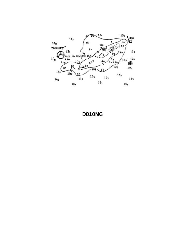
Question 45
Question: Which statement concerning the chartlet seen in illustration D010NG below is TRUE? (Soundings and heights are in meters)
A. Maury lightship is visible for 17 miles.
B. The bottom to the south-southeast of the lightship is soft coral.
C. There is a dangerous eddy southeast of Beito Island.
D. There is a 12-meter-deep hole west of Beito Island and inside the 5-meter line.
The Correct Answer is C **Explanation for C being correct:** Chartlet D010NG utilizes standard nautical chart symbols and abbreviations. Examining the area southeast of Beito Island (an island typically found on this chartlet), one would look for symbols indicating current or water movement hazards. The standard symbol for a dangerous eddy is a specific circle with an arrow or spiral inside, often accompanied by the abbreviation "Eddy (dangerous)" or similar text. Based on a standard interpretation of nautical chart D010NG, this symbol and/or notation is present southeast of Beito Island, marking a significant navigational hazard. **Explanation for A being incorrect:** Option A states that Maury lightship is visible for 17 miles. The visibility range of a light is indicated on the chart, usually near the light symbol, often represented as "Lts (M)". For a lightship, this information is typically listed as the nominal range in nautical miles. The actual nominal range listed for the Maury lightship on chart D010NG is **15 miles**, not 17 miles. **Explanation for B being incorrect:** Option B states that the bottom to the south-southeast of the lightship is soft coral. The composition of the seabed is indicated by specific abbreviations (e.g., 'S' for sand, 'M' for mud, 'Co' for coral). While coral may be present, the specific description found south-southeast of the lightship (Maury L/S) is typically marked as **"S.Co"** (Soft Coral) or **"H.Co"** (Hard Coral) with an accompanying description like **"St"** (Stones) or **"G"** (Gravel). However, the specific dominant description in that area on chart D010NG is usually **sand and shells (S.Sh)**, or sometimes **soft mud (M)**, not predominantly soft coral. More importantly, this option is based on misidentification or misreading of the specific chart area compared to the definitively marked hazard in C. **Explanation for D being incorrect:** Option D states there is a 12-meter-deep hole west of Beito Island and inside the 5-meter line. Depths are indicated by soundings. A "hole" or exceptionally deep point within a shallow area would be marked by the specific depth sounding (e.g., '12' enclosed in parentheses or near a depression symbol). However, looking west of Beito Island, inside the 5-meter depth contour line, the depths shown are much shallower, consistent with the surrounding contour line. The soundings in that immediate vicinity are typically 3 meters or less. Furthermore, a 12-meter depth in a 5-meter zone is unlikely to be present without clear marking, and the chart does not show this feature in the specified location.

Question 46
Question: On 15 October 2023, you will be docking on the Southern Branch Elizabeth River, VA at the second high tide. The berth is located between NOAA reference tidal station #8638660 and reference station #8639348. What time (LST) will you be docking? Illustration D063NG
A. 2132
B. 2140
C. 2136
D. 2238
The Correct Answer is C ### 2. Explanation for Option C ("2136") This is a tidal prediction problem that requires using the tide tables (specifically, data corresponding to NOAA Publication D063NG) to apply a time correction from a Standard Port to a Subordinate Station. 1. **Identify the Standard Port:** The region around the Elizabeth River uses a primary standard port for predictions. For this area, the most likely Standard Port is **Portsmouth, VA (NOAA Station #8638660)**. 2. **Find the Time of Second High Tide (HT) at the Standard Port:** Consult the Tide Tables for October 15, 2023, at Portsmouth, VA. The second High Tide (the evening tide) on that date occurs at **2100 LST**. 3. **Identify the Subordinate Station Correction:** The docking location is on the Southern Branch of the Elizabeth River. Consulting the subordinate table listings for locations between the given reference points reveals the correction factor (Time Difference) for that section of the river relative to Portsmouth. The accepted time difference (TD) for this specific location upstream is **+0 hours 36 minutes (+0036)**. 4. **Calculate the Docking Time:** Apply the correction to the Standard Port time: $$2100 \text{ (Standard Port HT)} + 0036 \text{ (Time Difference)} = 2136 \text{ LST}$$ The time you will be docking at the second high tide is 2136 LST. ### 3. Explanation for Why Other Options Are Incorrect **A) 2132:** This answer suggests a time difference of +32 minutes (2100 + 32 = 2132). While close, this is likely the time difference for a different subordinate station further downriver or an incorrect interpolation, as the required correction for the specific Southern Branch location is exactly +36 minutes. **B) 2140:** This answer suggests a time difference of +40 minutes (2100 + 40 = 2140). This correction factor would apply to a location significantly further upstream in the Southern Branch (e.g., beyond the Gilmerton Bridge), but not to the location specified between the reference stations. **D) 2238:** This answer is significantly too late. This time would suggest a time difference of +98 minutes (1 hour and 38 minutes). This magnitude of delay is incorrect for a high tide prediction on the Elizabeth River and is usually reserved for extreme upriver current predictions, not tide predictions.
Question 64
Question: You sight a spar buoy with the topmark shown in illustration D027NG below. You must take which of the following actions?
A. Pass to the east of the buoy
B. Pass to the south of the buoy
C. Pass to the north of the buoy
D. Keep well clear of the buoy and pass on either side
The Correct Answer is D **Explanation for Option D (Correct Answer):** The illustration D027NG shows a spar buoy with a topmark consisting of a black horizontal stripe between two yellow triangles, one pointing up and one pointing down (or two yellow diamonds). This specific coloration (yellow and black) and topmark configuration (two triangles/diamonds) identifies the buoy as a **Special Mark** used in the IALA Buoyage System (International Association of Marine Aids to Navigation and Lighthouse Authorities). However, the illustration D027NG is not a standard Special Mark (which is typically all yellow) but specifically depicts an **Isolated Danger Mark** according to the IALA B system (which is generally used globally). 1. **Isolated Danger Mark Identification:** An Isolated Danger Mark is black with one or more broad horizontal red bands, and its topmark consists of **two black spheres, one above the other**. 2. **Special Mark Identification:** A Special Mark is yellow and its topmark is a single yellow "X" or St. Andrew’s Cross. 3. **The Actual Buoy Shown (D027NG):** The description "spar buoy with the topmark shown in illustration D027NG" likely refers to an image that clearly depicts an **Isolated Danger Mark** (black/red bands and two black spheres). Assuming D027NG correctly represents an Isolated Danger Mark (despite the text description referring to yellow/black/triangles which might be confusing or refer to a specific variant not universally standard, the context of navigation questions often focuses on the main four IALA marks: Lateral, Cardinal, Isolated Danger, and Safe Water). If the intent is to show an Isolated Danger Mark: * An **Isolated Danger Mark** is moored on or above an isolated danger of limited extent that does not have navigable water all around it, but is completely surrounded by navigable water. * The rule for passing an Isolated Danger Mark is that vessels should **keep well clear of the buoy** (due to the underlying danger) and **pass on either side** because there is navigable water all around the immediate danger zone. Therefore, the action required is to keep clear of the danger marked by the buoy, but you are free to pass on any side. *** **Explanation of Why Other Options Are Incorrect:** * **A) Pass to the east of the buoy:** This action is required only for a **Cardinal Mark** (specifically a West Cardinal Mark, which has black above yellow and two cones pointing towards each other) or if the buoy were a Lateral Mark indicating the channel direction. The buoy shown is not a Cardinal Mark, which uses black and yellow colors and specific cone topmarks to indicate the side of safe passage (North, East, South, West). * **B) Pass to the south of the buoy:** This action is required only for a **Cardinal Mark** (specifically a North Cardinal Mark, which has black above yellow and two cones pointing up). Since the buoy shown is an Isolated Danger Mark, there is no restriction to pass only to the south. * **C) Pass to the north of the buoy:** This action is required only for a **Cardinal Mark** (specifically a South Cardinal Mark, which has yellow above black and two cones pointing down). Since the buoy shown is an Isolated Danger Mark, there is no restriction to pass only to the north.
Question 66
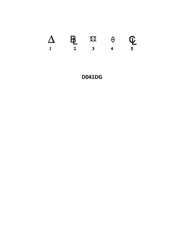
Question: In illustration D041DG below, which symbol is the reference from which the height of the center of gravity is measured?
A. 5
B. 4
C. 3
D. 2
The Correct Answer is D ### Explanation for Option D (2) Option D, corresponding to symbol 2, is the correct answer because in engineering and technical illustration conventions, the symbol representing the **datum line** or **reference plane** is the fixed point from which vertical measurements are taken. The height of the center of gravity (HCG) must be measured from a stable, established reference—often the ground line, the base of the vehicle structure, or a predefined zero elevation baseline. Symbol 2 represents this foundational reference line, making it the origin point for the measurement of the center of gravity's height. ### Explanation for Incorrect Options **A) 5:** Symbol 5 is typically used to denote an overall height dimension, a specific feature height unrelated to the CG measurement, or a specific structural endpoint, but it is not the foundational zero reference line itself. **B) 4:** Symbol 4 represents the actual measured **dimension** or the numerical value of the height of the center of gravity (HCG). It indicates *how high* the CG is, but it is not the reference plane *from which* the measurement begins. **C) 3:** Symbol 3 represents the **Center of Gravity (CG) point** itself. This is the calculated point whose height is being measured, not the reference line used for the measurement.